Approximate Location Map
Large Map »
Latitude: 51.6684 / 51°40'6"N
Longitude: -4.7192 / 4°43'9"W
OS Eastings: 212055
OS Northings: 200124
OS Grid: SN120001
Mapcode National: GBR GD.RZ23
Mapcode Global: VH2PS.5B0C
Plus Code: 9C3QM79J+98
Entry Name: West Set of Kilns
Listing Date: 26 April 1996
Last Amended: 26 April 1996
Grade: II*
Source: Cadw
Source ID: 16918
Building Class: Industrial
ID on this website: 300016918
Location: At the S side of the main private road entering the Kiln Park caravan site, on the E side of the A4139. They are related to the extensive Black Rock quarries at their rear.
County: Pembrokeshire
Community: Penally (Penalun)
Community: Penally
Locality: Kiln Park
Built-Up Area: Penally
Traditional County: Pembrokeshire
Tagged with: Kiln
History: The origins of the kilns at Kiln Park are obscure. The name John Nash has been traditionally suggested strongly in this connection, and has led to the notion that the celebrated architect (who died in 1835) might have been involved. But there was also a colliery blacksmith of that name, born in 1808, living in Saundersfoot in 1861. A surviving deed shows him to have been a substantial person, trustee for some property in the period 1854 to 1875. As the GROUPED KILNS at Kiln Park are evidently a consequence of the great exploitation of the Black Rock Quarry made possible by the coming of the Pembroke and Tenby railway in 1863, it is to the latter John Nash that the credit may be due, if there is any truth in the tradition at all.
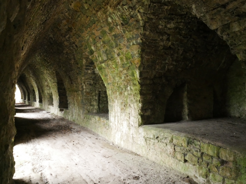
Description: Aset of six large limekilns with covered passage, built against a N-facing quarry face. Hammer-dressed limestone with a slight batter to buttressed wall enclosing kilns and passage. The passage formerly housed a railway line and has steep entrance arches in its E and W ends, and 5 lower segmental arches in the long N wall, together with 4 semi-circular windows or ventilators. Steeply vaulted interior. Each kiln has drawing holes to E and W, opening off access vaults divided by stone piers to form a row of 12 steeply pointed vaults. Access arches through the intervening piers align with the drawing holes and there are shutes from each kiln which permitted the direct loading of lime into wagons.
Listed II* an impressive and well-preserved example of limekilns of the railway era forming part of a group with the other kilns at Kiln Park.
Part of Ancient Monument No. Pe 436
References: Haverfordwest R.O. D/LJ/1261 (Nash deed, 1875); St Issells Census, 1861.
External links are from the relevant listing authority and, where applicable, Wikidata. Wikidata IDs may be related buildings as well as this specific building. If you want to add or update a link, you will need to do so by editing the Wikidata entry.


Other nearby listed buildings
