History in Structure

Memorial to Crawshay Bailey to SW of Parish Church of St Faith

A Grade II Listed Building in Llanfoist, Monmouthshire

More Photos »
Approximate Location Map
Large Map »

Coordinates

Latitude: 51.8126 / 51°48'45"N

Longitude: -3.0364 / 3°2'11"W

OS Eastings: 328647

OS Northings: 213174

OS Grid: SO286131

Mapcode National: GBR F4.WZCK

Mapcode Global: VH796.BP3T

Plus Code: 9C3RRX77+3C

Entry Name: Memorial to Crawshay Bailey to SW of Parish Church of St Faith

Listing Date: 15 March 1996

Last Amended: 15 March 1996

Grade: II

Source: Cadw

Source ID: 17229

Building Class: Commemorative

ID on this website: 300017229

Location: Situated at the upper, southern, end of the churchyard.

County: Monmouthshire

Community: Llanfoist Fawr (Llan-ffwyst Fawr)

Community: Llanfoist Fawr

Locality: Llanfoist

Built-Up Area: Llanfoist

Traditional County: Monmouthshire

Tagged with: Grave Memorial

Find accommodation in
Govilon

History

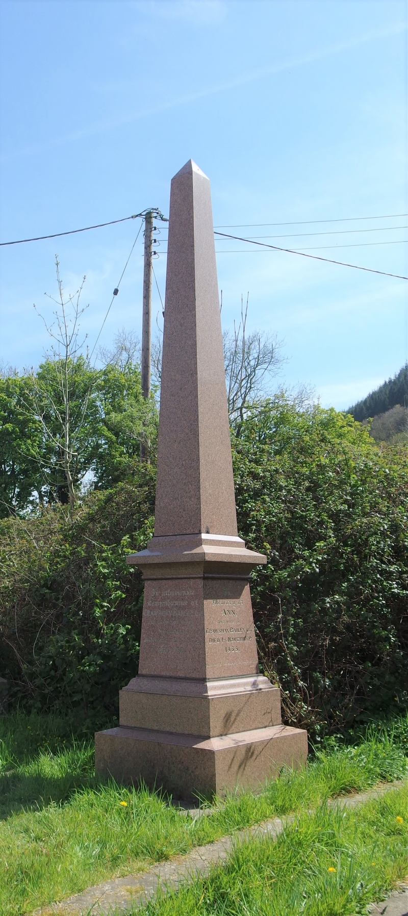
Crawshay Bailey (1789 - 1872) was a leading ironmaster and MP for Newport. He was also a pioneer of the coal industry and promoter of railways. As such he was an immensely powerful industrialist in the history of South Wales. He retired to Llanfoist House and died on 9th January 1872.

Exterior

Polished pink granite monument composed of a tall obelisk set on a squared pedestal with cornice. Simply inscribed in memory of Crawshay Bailey and his wife, Ann, who predeceased him in 1865. The monument is simply signed 'Evans'.

Reasons for Listing

Included for its special historic interest and for group value with the Parish Church of St Faith.

External Links

External links are from the relevant listing authority and, where applicable, Wikidata. Wikidata IDs may be related buildings as well as this specific building. If you want to add or update a link, you will need to do so by editing the Wikidata entry.

Recommended Books

Other nearby listed buildings

  • II Churchyard Cross at Parish Church of St Faith
    Situated close to the south porch of the church, beside the lime avenue.
  • II Parish Church of St Faith
    On the western edge of the village and set in the slope of the circular churchyard with a lime avenue. The churchyard entrance is at the junction of Llanellen Road and the B4246 Merthyr Road.
  • II Coach-house and stables to E of South Lodge
    South Lodge is set above the road to the west of Church Lane and the Parish Church of St Faith; the coach-house is below, and immediately to the left of, the house.
  • II South Lodge
    Above the road and set in its own grounds, immediately to the west of Church Lane and the Parish Church of St Faith.
  • II Glan nant-y-llan
    Situated in its own grounds to north of the Parish Church.
  • II Flight of steps to E of tunnel under canal
    At Llanfoist Wharf which is situated uphill to the south-west of Llanfoist Parish Church. Also passes under Boathouse Cottage.
  • II Bridge over Canal at Llanfoist Wharf
    Spanning the canal at Llanfoist Wharf and now serving as the access to Boathouse Cottage. Also known as Tod's Bridge.
  • II Llanfoist Wharf Boathouse, Beacon Park Boats
    At Llanfoist Wharf which is situated uphill to the south-west of Llanfoist Parish Church. The wharf is on the west side of the canal and the Boathouse is set to the north of the former tramway.

BritishListedBuildings.co.uk is an independent online resource and is not associated with any government department. All government data published here is used under licence. Please do not contact BritishListedBuildings.co.uk for any queries related to any individual listed building, planning permission related to listed buildings or the listing process itself.

British Listed Buildings is a Good Stuff website.