Latitude: 51.7245 / 51°43'28"N
Longitude: -4.8248 / 4°49'29"W
OS Eastings: 204995
OS Northings: 206639
OS Grid: SN049066
Mapcode National: GBR GB.QFBD
Mapcode Global: VH2PB.BX5D
Plus Code: 9C3QP5FG+Q3
Entry Name: Cresswell Quay Bridge
Listing Date: 8 April 1997
Last Amended: 8 April 1997
Grade: II
Source: Cadw
Source ID: 18296
Building Class: Transport
ID on this website: 300018296
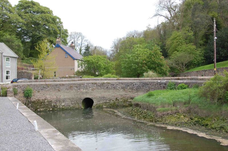
Location: Bridge crossing a minor tributary of the Cresswell River immediately to the S of the Quay. The stream is the Martletwy/Jeffreyston boundary.
County: Pembrokeshire
Community: Jeffreyston
Community: Jeffreyston
Locality: Cresswell Quay
Traditional County: Pembrokeshire
Tagged with: Bridge Road bridge
Late C18 bridge crossing the Treen Bridge Lake adjacent to Cresswell Quay. It was not adopted as a County Bridge.
Bridge of local rubble sandstone with a small archway. Low parapets, about 0.8 m high. The bridge has probably been greatly widened on the E side, as it is now considerably wider than the road from Pisgah approaching it; but a similar stonework E parapet has been constructed. The W parapet has a rounded cemented coping, the E parapet has a similar coping brought to an apex.
On the W side the parapet follows a broad curve and its S end abuts the gate-pier of Cresswell House. Its N end returns for a short distance and abuts the roadside wall of the Cresswell Quay.
Listed, notwithstanding its widening, for group value as an important visual link between the other listed buildings of Cresswell Quay (Cresselly Arms, Cresswell Quay and Cresswell House).
External links are from the relevant listing authority and, where applicable, Wikidata. Wikidata IDs may be related buildings as well as this specific building. If you want to add or update a link, you will need to do so by editing the Wikidata entry.


Other nearby listed buildings