Approximate Location Map
Large Map »
Latitude: 52.831 / 52°49'51"N
Longitude: -4.5318 / 4°31'54"W
OS Eastings: 229534
OS Northings: 328944
OS Grid: SH295289
Mapcode National: GBR 55.TPMB
Mapcode Global: WH44V.C37J
Plus Code: 9C4QRFJ9+97
Entry Name: Lychgate to Church of St Cian
Listing Date: 1 April 1998
Last Amended: 1 April 1998
Grade: II
Source: Cadw
Source ID: 19614
Building Class: Religious, Ritual and Funerary
ID on this website: 300019614
Location: Situated in Llangian village at W entrance to churchyard.
County: Gwynedd
Town: Pwllheli
Community: Llanengan
Community: Llanengan
Locality: Llangian
Traditional County: Caernarfonshire
Tagged with: Lychgate
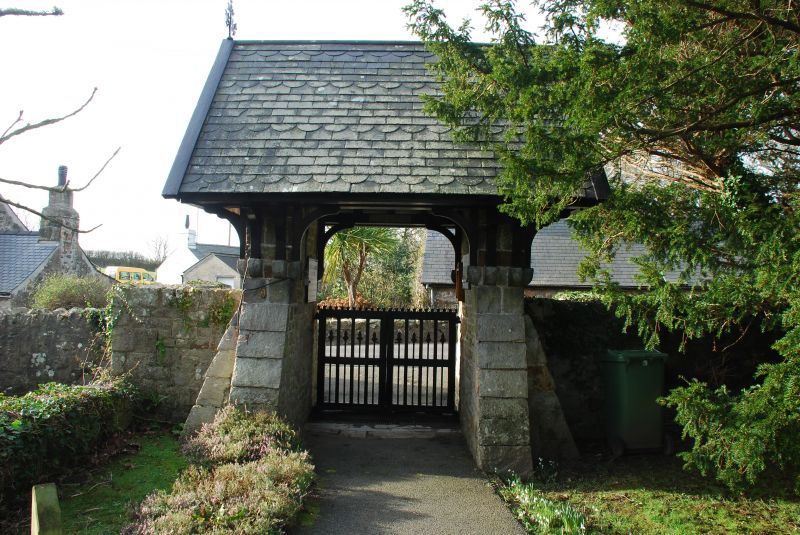
Lychgate to the Church of Saint Cian, built 1863 at the expense of Richard and Mary Lloyd Edwards of Nanhoron. An unusual design in the use of half-timber with stone, more typical of the 1870s and later.
Lychgate, two squared-stone side walls with raking clasping buttresses to about 1m height each end, and row of close-set small stone corbels to hold the timber brackets that carry an oversailing slate roof. Fishscale slate bands, long sawn slate copings, roll-topped ridge and ornate High Victorian wrought iron leafy cross finials. Black painted brackets curve out from corbels to carry horizontal beams on all 4 sides, two brackets to each wall-end, five to each wall outer side and another just inside the inner wall carrying an inner beam. Gable end 5 brackets carry a detached open-work timber framing of king-post, mid-rail and vertical struts. Paired front wooden gates with iron cresting and bars between uprights. Low stone walls with squared rough stone copings extend out each side of front and then come forward towards road.
A well-designed Victorian lychgate, presumably by an architect of note.
External links are from the relevant listing authority and, where applicable, Wikidata. Wikidata IDs may be related buildings as well as this specific building. If you want to add or update a link, you will need to do so by editing the Wikidata entry.


Other nearby listed buildings
