Approximate Location Map
Large Map »
Latitude: 51.5971 / 51°35'49"N
Longitude: -3.1382 / 3°8'17"W
OS Eastings: 321254
OS Northings: 189307
OS Grid: ST212893
Mapcode National: GBR HZ.BR9Z
Mapcode Global: VH6DV.K490
Plus Code: 9C3RHVW6+RP
Entry Name: Church of St John
Listing Date: 8 February 1999
Last Amended: 8 February 1999
Grade: II
Source: Cadw
Source ID: 21308
Building Class: Religious, Ritual and Funerary
ID on this website: 300021308
Location: Located in a high position on the E side of Machen village. Surrounded by a churchyard, from which the ground falls to the south towards the A468.
County: Caerphilly
Town: Caerphilly
Community: Bedwas, Trethomas and Machen (Bedwas, Tretomos a Machen)
Community: Bedwas, Trethomas and Machen
Locality: Machen
Built-Up Area: Machen
Traditional County: Monmouthshire
Tagged with: Church building
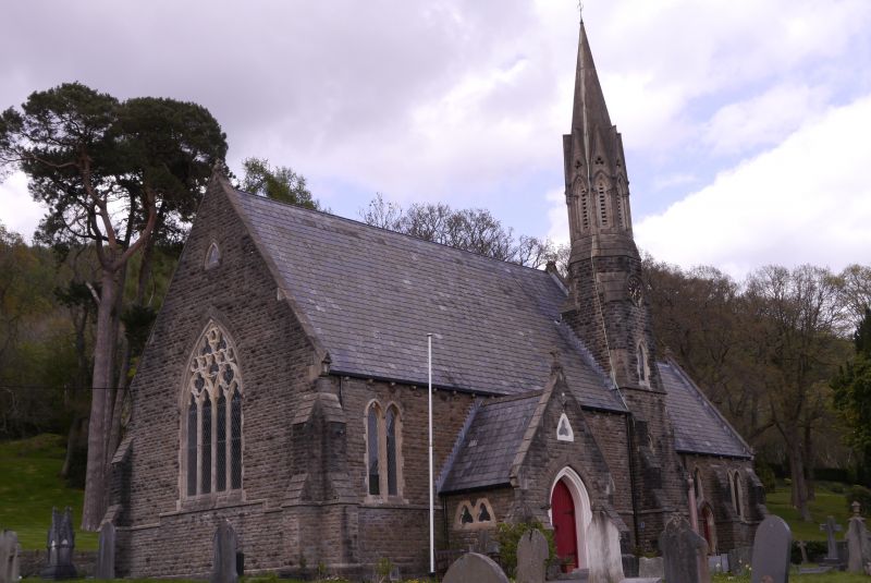
Designed by W. G. & E. Habershon of London and Newport. Built in 1854-5 by Edey & Basford of St Neots and Mr Knight of Exeter. The architects acted for the Tredegar Estate from this time, and also built the Church of St Mary at Risca in 1851. The need for a new church in Upper Machen, to compliment St Michael's in Lower Machen, was due to the rapid rise in population caused by industrialisation. In 1854, the rector opened a subscription list and soon had over £1,000. £400 was donated by Edward Buller, proprietor of Machen Colliery. Interestingly, the list of subscribers included non-conformists who were subsequently involved in the church. Some services were undertaken in Welsh.
Repairs to the church were undertaken from 1860, the steep pitch of the roof causing problems with damp. In 1952 the steeple was rebuilt. The unusual position and polygonal shape of the spire recalls the medieval steeple at Lostwithiel (Cornwall).
Nave, chancel, S porch, N vestry, steeple to SE angle of nave. Mixed Early English and Geometric styles. Constructed of coursed, rock-faced stone under steeply pitched slate roofs. String course, plinth, and stepped angle buttresses. Corbelled eaves with foliate bosses, and raised copings. Lancet windows, mainly paired, with sandstone dressings and hoodmoulds with end stops. Large porch offset to L of centre of nave, flanked by paired lancets. Wide pointed-arched entrance with hollow mouldings containing planked double doors. Trefoil to apex and paired trefoils to sides. Short 3-stage steeple with angle buttresses to S and E. Single lancet to 1st stage. Shorter lancet to 2nd stage with clock above in sandstone surround with inscription 'watch and pray'. Second lancet to E face. The angles of the 2nd stage are slightly rounded, with sandstone broach stops. The top stage is octagonal and built of sandstone, with lancet-shaped louvres between colonnettes under steep gables with pierced trefoils. The spire rises above. The nave has a large 4-light W window in Geometric style with cusped lancets and cusped trefoils and quatrefoils above. Trefoil to gable apex. The N wall of the nave has 4 pairs of lancets separated by angle buttresses.
The S side of the chancel has 3 bays divided by stepped buttresses. The outer bays have paired lancets. The inner bay has a pointed-arched priest's door in a sandstone surround with hollow mouldings. The L side of the arch head cuts into the base of a lancet window, perhaps rather awkwardly, but the 2 are contemporary. Four-light E window in Geometric style, with cusped lancets and trefoils and sexfoil above. Lean-to vestry to N with 3 trefoiled lights in heavy surround. Planked door to E end of vestry in heavy surround with shouldered lintel.
Undivided nave with 7-bay roof, the E bay wider. High hammer-beam roof supported on corbels. Alternate corbels are at wall-plate level and bear gold-painted head bosses. Pierced cinquefoils above collar trusses. Tall chancel arch with several orders of mouldings, the inner ones supported by corbels, beneath which are head bosses, one a man, the other a woman. Behind the pulpit is an octagonal pier with capital which supports the NW angle of the tower. Pointed arches with chamfered reveals spring from the pier and form the N and W internal sides of the steeple. The stone pulpit is polygonal with blind arches, supported on a short octagonal pedestal. The octagonal font has incised quatrefoils, on a stem composed of 4 columns, on a large octagonal plinth. Simple porch with recesses for the paired trefoiled lights.
The chancel has a 3-bay arched brace roof, the trusses supported on plain corbels. Pointed arch to vestry doorway. The tracery lights of the W window and the S chancel windows have stained glass in a geometric design. The E window is dedicated to William Rees Lloyd (d. 1919). Flanking the E window are 2 blind lancets in which are written biblical texts. Memorial plaque on N wall of chancel to W. Darby, son of the rector, who died in 1915 in the Great War.
Listed as an early Victorian church of unusual and distinctive style built to serve a burgeoning industrial population. The internal focus on the pulpit owes something to the preaching churches of the C18, but may also have been influenced by non-conformist participation.
External links are from the relevant listing authority and, where applicable, Wikidata. Wikidata IDs may be related buildings as well as this specific building. If you want to add or update a link, you will need to do so by editing the Wikidata entry.


Other nearby listed buildings
