Latitude: 53.2077 / 53°12'27"N
Longitude: -3.1296 / 3°7'46"W
OS Eastings: 324649
OS Northings: 368446
OS Grid: SJ246684
Mapcode National: GBR 70.1VN5
Mapcode Global: WH76Z.WMWR
Plus Code: 9C5R6V5C+34
Entry Name: Former Stables at Lislea House
Listing Date: 19 April 1999
Last Amended: 15 August 2001
Grade: II
Source: Cadw
Source ID: 21617
Building Class: Domestic
ID on this website: 300021617
Location: To the S of the church, the N wall bounding the road, the S side facing into a courtyard behind the house.
County: Flintshire
Town: Mold
Community: Northop (Llaneurgain)
Community: Northop
Built-Up Area: Northop
Traditional County: Flintshire
Tagged with: House
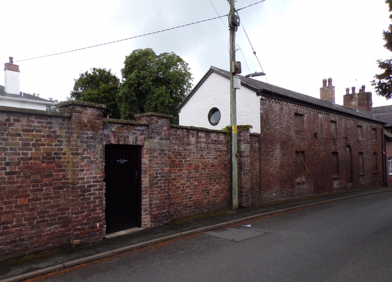
Stable block probably contemporary with the former vicarage which was constructed in 1826. Shown on the Northop tithe map of 1839.
Two ranges at right angles bounding a courtyard. Main 2-storey range oriented E-W constructed of Flemish bond brickwork under a slate roof with cut-down chimney stack to N. The S (courtyard) side is whitened; on the upper floor is a small square boarded window to L and an oculus towards centre. Between the 2 is a small opening containing 3 dove holes. On ground floor, from L, double planked doors with flat brick head; small 2-light window; broad entrance with double planked doors under a concrete lintel, immediately R of which is a 2-light window under a segmental brick head. To the R, is a small 2-light window followed by a single stable door under a segmental brick head. The E gable end has a single boarded oculus. The N elevation, facing Church Road, is unpainted and has blind door and window openings imitating a 2-storey, 4 window house. Round arched doorway flanked by pairs of windows, which have flat-arched brick heads and brick sills. Shorter windows aligned above. The elevation has 5 small vents.
The W gable end adjoins a further lower range at right angles (the rear wing of the Old Police Station), also of brick with a slate roof. This has a narrow 4-pane window to the R and a wider opening to the L with brick lintel. To its R is an infilled dove hole. Timber ridge ventilator with weather vane to L, beyond which is an added bay with wide entrance and long timber lintel containing double planked doors.
No access to interior at time of inspection.
Listed as an early C19 stable block retaining its character, the imitation house facade to the road side of additional interest.
Group value with Lislea House (former vicarage).
External links are from the relevant listing authority and, where applicable, Wikidata. Wikidata IDs may be related buildings as well as this specific building. If you want to add or update a link, you will need to do so by editing the Wikidata entry.


Other nearby listed buildings