Approximate Location Map
Large Map »
Latitude: 53.2078 / 53°12'28"N
Longitude: -3.1302 / 3°7'48"W
OS Eastings: 324613
OS Northings: 368457
OS Grid: SJ246684
Mapcode National: GBR 70.1VJ8
Mapcode Global: WH76Z.WMMP
Plus Code: 9C5R6V59+4W
Entry Name: Entrance Piers, Gates and Boundary Wall to Church of St Eurgain and St Peter
Listing Date: 15 August 2001
Last Amended: 15 August 2001
Grade: II
Source: Cadw
Source ID: 25678
Building Class: Religious, Ritual and Funerary
ID on this website: 300025678
Location: The wall bounds the S, W and N sides of the churchyard with the main entrance to the SW corner.
County: Flintshire
Town: Mold
Community: Northop (Llaneurgain)
Community: Northop
Built-Up Area: Northop
Traditional County: Flintshire
Tagged with: Gate
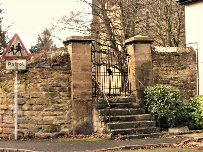
The W wall bears a datestone of 1837, though some of the walling may be earlier and relate to the original rectangular churchyard. The style of the masonry piers suggests that they are contemporary with the remodelling of the church in 1839-40. In 1866 the churchyard was extended to the N, with a further extension to the NE in 1911.
Square entrance piers of dressed pecked sandstone on tall plinths. The piers have shallow moulded pyramidal capstones. Double cast iron entrance gates with bands of quatrefoils to bottom rails and beneath lock level. Trefoiled heads beneath top rails, which have a frieze of squares, and stylised fleur-de-lis finials. The gates are approached by 5 stone steps with chamfered corners. From here, a path leads N towards the porch, bound on the E side by plain iron railings with fleur-de-lis finials. Adjoining the entrance are boundary walls of rubble sandstone with saddleback stone copings. Along the W side, a partly eroded stone tablet is built into the wall. It is dated 1837 and refers to the church wardens, Thomas Tomlinson and Edward Jones. To its L is an entrance into the graveyard with square stone piers and capstones and gates with plain railings. The boundary wall continues around the S side of the graveyard, then curves round at the SE corner where it joins houses. There is a further entrance here with square piers of dressed pecked sandstone and capstones as main entrance. A flight of 6 stone steps with plain iron railings leads to double cast iron gates, plain except for figure-of-eight motifs towards the outer sides.
Listed as a good, largely C19 boundary including a fine entrance; group value with the church and grammar school.
External links are from the relevant listing authority and, where applicable, Wikidata. Wikidata IDs may be related buildings as well as this specific building. If you want to add or update a link, you will need to do so by editing the Wikidata entry.


Other nearby listed buildings
