Approximate Location Map
Large Map »
Latitude: 53.2078 / 53°12'28"N
Longitude: -3.1294 / 3°7'45"W
OS Eastings: 324668
OS Northings: 368453
OS Grid: SJ246684
Mapcode National: GBR 70.1VQQ
Mapcode Global: WH76Z.XM0P
Plus Code: 9C5R6V5C+47
Entry Name: Boundary Wall to N of Lislea House
Listing Date: 15 August 2001
Last Amended: 15 August 2001
Grade: II
Source: Cadw
Source ID: 25679
Building Class: Domestic
ID on this website: 300025679
Location: Fronting the road and forming the N boundary to the grounds of Lislea House. The wall adjoins the former stables to the W.
County: Flintshire
Town: Mold
Community: Northop (Llaneurgain)
Community: Northop
Built-Up Area: Northop
Traditional County: Flintshire
Tagged with: House
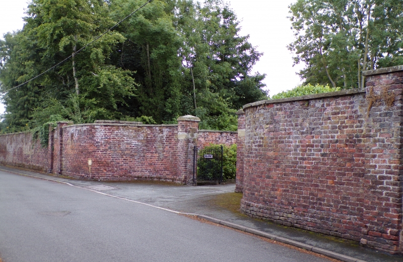
Probably of 1826 and contemporary with the former vicarage (now Lislea House) and the stable block.
High red brick wall in English bond with flat stone copings and brick plinth. To the far R, close to the former stables, is a square brick pier with monolithic stone band and flat capstone. To its L is a narrow entrance with similar piers but without stone bands, blocked with C20 red brick. The main entrance to Lislea House is to the L. Quadrant walls curve in towards brick piers with stone bands, between which are low cast iron gates with scrolls to the top and bottom rails and no finials. Panels reading 'Lislea' and 'House' are fixed to the gates. To the L of the main entrance is a 2nd narrow entrance with piers as before. It has a shallow segmental brick head and is blocked with C20 red brick. The wall continues for some distance to the E where there is a pair of square sandstone piers with plain capstones, between which are C20 wooden garage doors. The wall terminates with a square pier. A further wall runs behind at right angles.
Listed as a long boundary wall which adds character to the streetscape. Group value with Lislea House (former vicarage) and stable block.
External links are from the relevant listing authority and, where applicable, Wikidata. Wikidata IDs may be related buildings as well as this specific building. If you want to add or update a link, you will need to do so by editing the Wikidata entry.


Other nearby listed buildings
