Latitude: 51.6043 / 51°36'15"N
Longitude: -3.0771 / 3°4'37"W
OS Eastings: 325498
OS Northings: 190043
OS Grid: ST254900
Mapcode National: GBR J2.B2PN
Mapcode Global: VH7B4.MY31
Plus Code: 9C3RJW3F+P4
Entry Name: Canal Bridge over Monmouthshire and Brecon Canal S of Ty Sign
Listing Date: 22 October 1999
Last Amended: 22 October 1999
Grade: II
Source: Cadw
Source ID: 22512
Building Class: Transport
ID on this website: 300022512
Location: Towards the E community boundary , the E area of Pontymister, between Herbert Avenue to S and Manor Way to N, S of Ty Sign.
County: Caerphilly
Community: Risca East (Dwyrain Rhisga)
Community: Risca
Locality: Pontymister
Built-Up Area: Risca
Traditional County: Monmouthshire
Tagged with: Bridge
In 1790s a consortium of coal owners and industrialists sought Parliamentary approval to build canals to link the industrial areas of the N valleys with Newport on the Usk estuary, the canals in turn to link with a system of feeder tramroads. Bill received assent in 1792 and the Monmouthshire Canal Navigation Company was formed to build two canals; that in the Western Valley, also known as the Crumlin Arm and 11 miles long, was designed to join the Eastern Valley Canal just N of Newport, completed c 1797, engineer Thomas Dadford. Reservoirs to feed canal were constructed in mountain valleys. In 1865 the Brecknock and Abergavenny and Monmouthshire Canals merged to become the Monmouthshire and Brecon Canal which was later incorporated into the Great Western Railway. Much of the Western Valley canal was filled in to provide a by-pass road but the section through Risca mostly survives, continuing on from the surviving Crosskeys section. The Sirhowy tramroad built at the expense of the Sirhowy and Tredegar ironmasters from their furnaces in the north valleys to Nine Mile Point, at the bottom of the Sirhowy Valley, N of Risca was completed 1805, linking with the Monmouthshire Railway and Canal Company tramroad via the Long Bridge, crossing the Ebbw Valley.
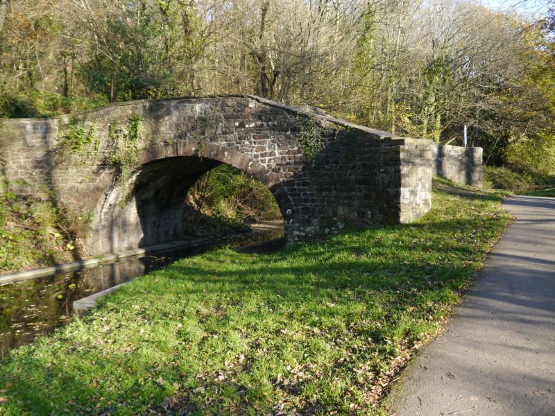
Asymmetrical hump-backed bridge of rubble sandstone. Single elliptical arch has dressed stone voussoirs and low parapet with flat coping. Abutments are splayed outwards and end in square piers. Former towpath passed under bridge to S where there is a stone kerb. Cobbled deck. Concrete repairs to coping.
Listed as a late C18 canal bridge retaining its character.
External links are from the relevant listing authority and, where applicable, Wikidata. Wikidata IDs may be related buildings as well as this specific building. If you want to add or update a link, you will need to do so by editing the Wikidata entry.


Other nearby listed buildings