Approximate Location Map
Large Map »
Latitude: 51.7083 / 51°42'29"N
Longitude: -3.133 / 3°7'58"W
OS Eastings: 321812
OS Northings: 201671
OS Grid: SO218016
Mapcode National: GBR J0.3DNT
Mapcode Global: VH6D8.NB27
Plus Code: 9C3RPV58+8R
Entry Name: Ty-llwyd
Listing Date: 26 November 1999
Last Amended: 26 November 1999
Grade: II
Source: Cadw
Source ID: 22672
Building Class: Domestic
ID on this website: 300022672
Location: Reached across field to NW of track leading from the Mount Pleasant estate to Aber-common.
County: Blaenau Gwent
Community: Llanhilleth (Llanhiledd)
Community: Llanhilleth
Locality: St Illtyd
Built-Up Area: Llanhilleth
Traditional County: Monmouthshire
Tagged with: Farmhouse
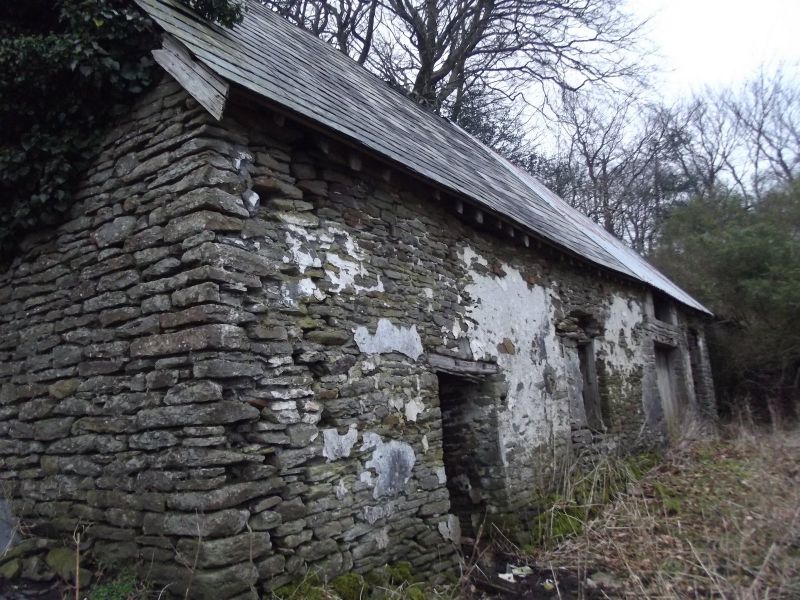
Early to mid C17, possibly with earlier origins: extended at N end c1700 to create large heated parlour, retaining former parlour as small central room. A cruck truss in the byre appears to be reused, and the hall truss is unusually close to the chimney: it is possible that Ty Llwyd was a C16 hall-house, heavily remodelled in the C17, when the hall chimney was inserted. Used as the parish vicarage after the Reformation. Tithe Map of 1843 shows Ty Llwyd as a smallholding of 7 acres (2.8 hectares): James Lewis, owner and Miles Lloyd, occupier. Now used for storage, the chimneys removed.
Rubble construction, with extensive patches of limewash remaining. Slate roof to front slope of byre; otherwise roof has been replaced in metal sheeting. Chimneys removed from both gable ends of house. House built into steep slope with large parlour at upper end, and byre downslope, below cross-passage. Long five-bay lofted front elevation facing E. Byre to left has doorway towards left end; timber lintel. To right of this is former cross-passage entry, reduced in width, and altered to form a window when a centralised entry was created in the C19. Elevation of house has wide inserted doors to right, with wide opening above under eaves. Inserted C19 doorway to centre. Right bay is slightly narrower in depth, where parlour end was extended: window with timber lintel, small window above. N end is built into steep bank. S gable end has massive sloping buttress to left. Rear elevation of byre has two window openings, with stone dripmoulds, the lower collapsing. Upper window originally door to cross-passage. To left is wide projection for chimney stair with catslide roof, the stair lit by a two-light diamond mullioned window. Above this, a blocked window, and then what appears to have been a door, reduced to form a window: the position of a door against the sloping ground is puzzling.
Hall has C19 fireplace with timber surround: large chimney stair to right with stone treads. C17 doorway to stair of timber, with segmental arched head: similar upper doorway. Cupboard recess to right of fireplace. Hall has beam-and-joist ceiling; straight-cut stops with fillets. Original entry from cross-passage into hall survives with segmentally-headed timber surround, and drawbar slot. Narrow central room (originally the parlour) divided from hall by post and panel partition, with single E doorway: plain matching outer doorways. Similar beams to hall. Stone dividing wall (originally the gable end) between central room and large added parlour. Parlour has heavy beams with long curved stops; altered fireplace. Recess to left of fireplace, possibly associated with former stair. Attic room above hall originally had an E dormer: central truss with curved feet, notched and lapped collar joints; triple trenched purlins. Attic room over parlour has similar truss. Cross-passage screen was removed in C19, when centralised entry was created between hall and parlour, and a fireplace inserted backing onto the hall chimney. Ceiling of cross-passage remains intact, with widely-spaced joists between beams. Byre originally lofted upon two beams, the lower one with angle stops. Loft accessed off (inserted?) door from head of hall stair. Byre has two trusses similar to the house, the lower one of fine quality with morticing for an earlier collar: i.e. possibly reused. Triple purlins.
Listed as a well-preserved C17 upland farmhouse, retaining unusual and early plan, and original internal detail.
External links are from the relevant listing authority and, where applicable, Wikidata. Wikidata IDs may be related buildings as well as this specific building. If you want to add or update a link, you will need to do so by editing the Wikidata entry.


Other nearby listed buildings
