Approximate Location Map
Large Map »
Latitude: 51.6687 / 51°40'7"N
Longitude: -2.8819 / 2°52'54"W
OS Eastings: 339108
OS Northings: 197023
OS Grid: ST391970
Mapcode National: GBR JB.63SL
Mapcode Global: VH7B2.0BB4
Plus Code: 9C3VM499+F7
Entry Name: Outbuilding at Ty Mawr
Listing Date: 22 June 2000
Last Amended: 22 June 2000
Grade: II
Source: Cadw
Source ID: 23495
Building Class: Agriculture and Subsistence
ID on this website: 300023495
Location: Range of outbuildings to SW of Ty Mawr, facing out to road.
County: Monmouthshire
Town: Usk
Community: Llantrisant Fawr
Community: Llantrisant Fawr
Locality: Llantrissent/Llantrisant
Traditional County: Monmouthshire
Tagged with: Appendage
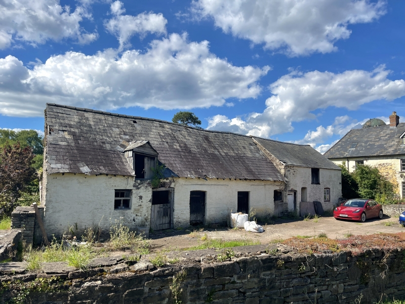
Range of outbuildings, lofted stable to right, cow-house to left, part lofted. Possibly C18, marked on 1840 Tithe Map, but stable altered or rebuilt in C19.
Range of outbuildings, colourwashed rubble stone with slate roofs. Two parts, long cow-shed range to left and lofted stable to right, to a single ridge line. Stable has centre square loft opening under eaves, ground floor casement pair to right, door and boarded window to left. Stone outside steps to loft door on right end wall. Brick cambered heads to openings.
Single storey range to left has 4 doors irregularly spaced, eaves gabled dormer to left of left door, and small window further left. Brick heads doors, timber lintel with brick relieving arch to second door.
Included as a small traditional range of outbuildings, of group value with Ty Mawr.
External links are from the relevant listing authority and, where applicable, Wikidata. Wikidata IDs may be related buildings as well as this specific building. If you want to add or update a link, you will need to do so by editing the Wikidata entry.


Other nearby listed buildings
