Latitude: 51.8127 / 51°48'45"N
Longitude: -3.1202 / 3°7'12"W
OS Eastings: 322871
OS Northings: 213272
OS Grid: SO228132
Mapcode National: GBR F1.WW3S
Mapcode Global: VH6CP.VPTQ
Plus Code: 9C3RRV7H+3W
Entry Name: Smart’s Bridge
Listing Date: 27 July 2000
Last Amended: 27 July 2000
Grade: II*
Source: Cadw
Source ID: 23813
Building Class: Transport
ID on this website: 300023813
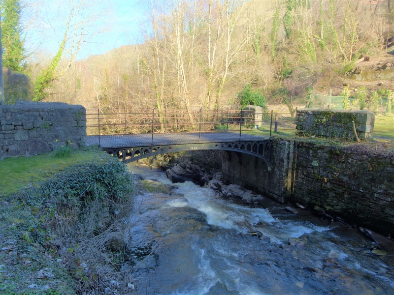
Location: Bridge is located over River Clydach forming entry to remains of Clydach Ironworks, reached off S side of road leading to Ynys-y-garth.
County: Monmouthshire
Community: Llanelly (Llanelli)
Community: Llanelly
Locality: Clydach
Built-Up Area: Clydach
Traditional County: Brecknockshire
Tagged with: Bridge
Cast-iron bridge dated 1824 probably built to link a tramroad from the Clydach Ironworks with the Clydach Railroad to the N. In 1824, one of the main partners of the works, Walter Powell died, and John Scale of Aberdare was appointed manager. The works probably begun in 1793, when a furnace was built, noted as the ‘new furnace’ in 1795. The land formed part of that leased by Edward and John Kendall from the Duke of Beaufort when the Beaufort Ironworks was set up: the Clydach Works was operated by Edward Frere and Thomas Cooke, with the Kendalls sharing the profits. The Duke of Beaufort forced a new lease in 1801, where Cooke and Frere formally subleased the site. In 1796, 1660 tons of iron was produced, and after a slump around 1803, the works produced 2658 tons in 1816. The business was offered for sale in 1813, described as having two furnaces with water-driven blast, and 600 acres (243 hectares). By now, the Clydach Iron Company had been formed, whose heavy investment resulted in debts of around £24,000. The works failed to sell, and by 1833 it was on the market again, with three furnaces. No purchasers were forthcoming, and by 1858, when loans were called in, the company was crippled by debt, closing in 1861. In 1864, the Clydach Sheet and Bar Iron Company bought the works for £6000, managed by John Jayne of Pantybeiliau, former truckmaster of Nantyglo. Sold to the Brynmawr Coal and Iron Company in 1873 for £220,000: they went into liquidation in 1877 and the works were then closed. Restored 1987 by Blaenau Gwent Borough Council.
Cast-iron bridge of wide single-span (2.9 metres) over rocky bed of River Clydach. Segmental arch with decorative spandrels having repeated lancets: dated 1824 on crown of arch to both sides. Surface of carriageway is iron-plated, grooved for rails, with transversse grips each side of grooves. Bridge is built off rubble piers, built on the rock. Simple iron railings added in 1987 (said to be similar to original ones), terminated in lengths of rubble walling.
Listed as a rare survival of an early C19 cast-iron bridge of impressive span and design. Important history, being part of the Clydach Ironworks, the major industry in the area from 1793 - 1878. The bridge is a prominent survival of the important industrial landscape of the Clydach Gorge.
Scheduled Ancient Monument BR161 (part).
External links are from the relevant listing authority and, where applicable, Wikidata. Wikidata IDs may be related buildings as well as this specific building. If you want to add or update a link, you will need to do so by editing the Wikidata entry.


Other nearby listed buildings