Latitude: 53.3145 / 53°18'52"N
Longitude: -4.5554 / 4°33'19"W
OS Eastings: 229862
OS Northings: 382773
OS Grid: SH298827
Mapcode National: GBR HM4Y.62F
Mapcode Global: WH42B.0Y1F
Plus Code: 9C5Q8C7V+QR
Entry Name: Agricultural range, Bodlasan Fawr
Listing Date: 19 December 2000
Last Amended: 19 December 2000
Grade: II
Source: Cadw
Source ID: 24475
Building Class: Agriculture and Subsistence
ID on this website: 300024475
Location: In an isolated rural location at the end of a single track road c 1.5km W of the village of Llanfachraeth. The range is to the S of the house.
County: Isle of Anglesey
Town: Holyhead
Community: Llanfachraeth
Community: Llanfachraeth
Traditional County: Anglesey
Tagged with: Architectural structure
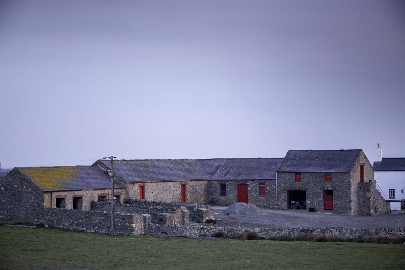
Early C20 agricultural range erected in 1906 and built to replace an earlier range on the site. An earlier range is shown on the OS 6" map 1887-8.
L-plan agricultural range, with a cartshed-granary and stable forming the foot of the 'L' and a hammel-cowhouse range forming the stem. Rubble walls with slate roof, ventilator ridge tiles and tiled gable copings. The openings have cambered brick arch heads with dripcourse. The hammel range has two paired doors, leading onto a stone walled hammel yard. To the R is a long cowhouse with door either end; the R unit leads into a feedroom at the angle. In the right hand range is a stable with central boarded split door and flanking windows. At the end of the range is a higher cartshed-granary with external stone stairs to the R gable end. Wide doorway to cartshed, with boarded split tackroom door to R. Two windows to the granary; slatted ventilator to lower part with 3 small square panes above. Similar windows to rear elevation. New window cut to tackroom rear.
Listed as a complete agricultural range dating from the early C20; one of the last agricultural ranges to be designed and built for pre-tractor farming methods. The range also forms part of the farmstead group along with the house and servant's quarters.
External links are from the relevant listing authority and, where applicable, Wikidata. Wikidata IDs may be related buildings as well as this specific building. If you want to add or update a link, you will need to do so by editing the Wikidata entry.


Other nearby listed buildings