Approximate Location Map
Large Map »
Latitude: 51.6619 / 51°39'42"N
Longitude: -3.2833 / 3°16'59"W
OS Eastings: 311332
OS Northings: 196682
OS Grid: ST113966
Mapcode National: GBR HS.6JTX
Mapcode Global: VH6DD.1HLB
Plus Code: 9C3RMP68+QM
Entry Name: Barn adjacent to Llancaiach Fawr
Listing Date: 18 July 2001
Last Amended: 18 July 2001
Grade: II
Source: Cadw
Source ID: 25538
Building Class: Agriculture and Subsistence
ID on this website: 300025538
Location: Adjacent to and parallel with the main entrance track to Llancaiach Fawr. At rear backs onto Nant Caeach.
County: Caerphilly
Community: Gelligaer
Community: Gelligaer
Locality: Llancaiach
Traditional County: Glamorgan
Tagged with: Barn
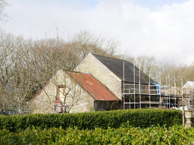
Probably C19. Shown on Tithe Map of 1842 and OS map of 1875, separated from the main house by an orchard.
Long barn range in two main units. Of narrow coursed rubble with some signs of former rendering and with Welsh slate roof. Right uphill barn unit (N) of 5 bays has a central double door, ventilation squares, a rectangular opening low to left. Small wing with ventilation slit now roofless attached at upper (N) end . Straight joint to left indicates the added range (S), probably a stable with hay loft which has 2 small cambered-headed windows with brick voussoirs and door, with loft opening above. To rear altered main double door opening, later breeze block lean-to ; downhill unit (S) has 3 high level ventilation slits to loft, doorway near end with stable doors and heavy stone lintel. Attached lower wing with wide cart/carriage arch.
Included as a large barn range for group value with Llancaiach Fawr.
External links are from the relevant listing authority and, where applicable, Wikidata. Wikidata IDs may be related buildings as well as this specific building. If you want to add or update a link, you will need to do so by editing the Wikidata entry.


Other nearby listed buildings
