History in Structure

Barn opposite St Beuno's Parish Church

A Grade II Listed Building in Llanycil, Gwynedd

More Photos »
Approximate Location Map
Large Map »

Coordinates

Latitude: 52.9012 / 52°54'4"N

Longitude: -3.6152 / 3°36'54"W

OS Eastings: 291455

OS Northings: 334967

OS Grid: SH914349

Mapcode National: GBR 6C.PBB9

Mapcode Global: WH675.FBQR

Plus Code: 9C4RW92M+FW

Entry Name: Barn opposite St Beuno's Parish Church

Listing Date: 22 October 2001

Last Amended: 22 October 2001

Grade: II

Source: Cadw

Source ID: 25806

Building Class: Agriculture and Subsistence

ID on this website: 300025806

Location: Prominently-sited on the roadside.

County: Gwynedd

Community: Llanycil

Community: Llanycil

Traditional County: Merionethshire

Tagged with: Barn

Find accommodation in
Bala Junction

History

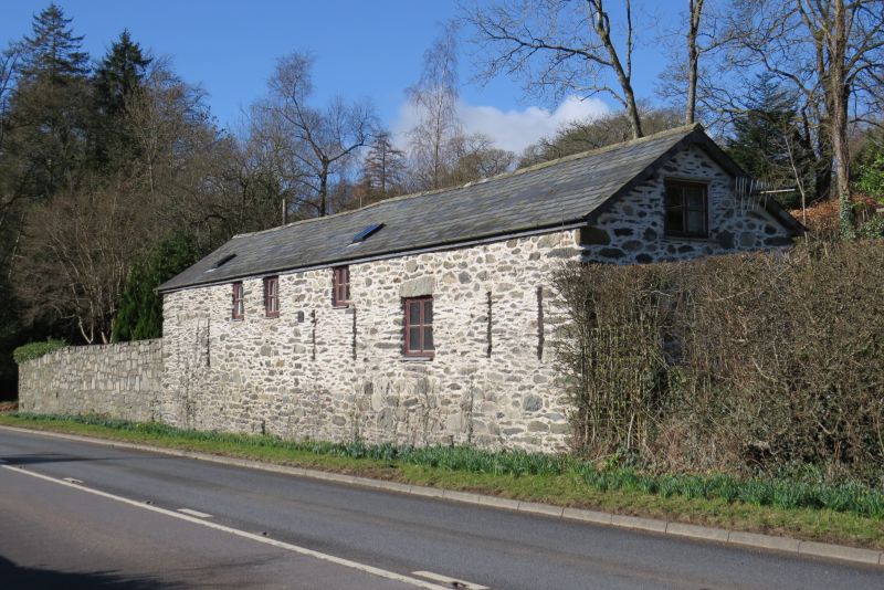
Late C18 or early C19 barn. The barn belonged to the former rectory and is traditionally known as the Tithe Barn.

Exterior

Long rectangular barn of 5 bays; rubble construction with slate roof. Irregular openings to the main (road-side) elevation: the L section has 2 rectangular loft openings under the eaves with long vent slit diagonally below to the L; the right-hand section has a further, centrally-placed rectangular loft opening with slatestone lintel and paired flanking vent slits. Further upper loft entrance to the R gable.

Interior

The interior was not inspected at the time of survey.

Reasons for Listing

Listed as a late C18 or early C19 barn retaining good original character in a prominent roadside location.

External Links

External links are from the relevant listing authority and, where applicable, Wikidata. Wikidata IDs may be related buildings as well as this specific building. If you want to add or update a link, you will need to do so by editing the Wikidata entry.

Recommended Books

Other nearby listed buildings

  • II Abercelyn
    Set back from the road within its own grounds, opposite the church and church yard.
  • II Llanycil Cottage
    Facing NE on a triangular site at the junction between the main road, along the shore of Bala Lake, and the by-road to Parc; set back behind a rubble walled forecourt.
  • II Parish Church of St Beuno including two C17 Chest Tombs adjoining at the SW Corner
    Set within its own walled churchyard on the banks of Bala lake, immediately to the SE of the main road.
  • II Bryn Tegid
    Located on a raised plateau overlooking Bala lake at the SW edge of Llanycil village; at the end of a lane running SW from the Llanycil - Parc road immediately past Llanycil Cottage.
  • II Plas Moel-y-Garnedd
    Set in its own extensive, landscaped grounds above Bala Lake, approximately 1km from Llanycil; accessed via a long drive running NW from the main road (A 494).
  • II Nant-y-Meirch Cottage and attached Agricultural Range
    Located uphill from, and NE of Plas Moel-y-Garnedd, and sited across the slope; faces NW. Plas Moel-y-Garnedd is set in its own landscaped grounds above Bala Lake; reached up long drive, 1km from Lla
  • II Stables and Coach house at Plas Moel-y-Garnedd
    Located uphill from, and to the NE of Plas Moel-y-Garnedd; sited across the slope, facing NW. Plas Moel-y-Garnedd is set in its own landscaped grounds above Bala Lake; reached up long drive, 1km from
  • II Fach Ddeiliog (Bala Lakeside Hotel)
    In an elevated position above the SE side of the B4403 at the N end of Lake Tegid.

BritishListedBuildings.co.uk is an independent online resource and is not associated with any government department. All government data published here is used under licence. Please do not contact BritishListedBuildings.co.uk for any queries related to any individual listed building, planning permission related to listed buildings or the listing process itself.

British Listed Buildings is a Good Stuff website.