History in Structure

Front Wall, Gatepiers and Gate of No 88 (Bridge House)

A Grade II Listed Building in Whitchurch, Cardiff

More Photos »
Approximate Location Map
Large Map »

Coordinates

Latitude: 51.5112 / 51°30'40"N

Longitude: -3.217 / 3°13'1"W

OS Eastings: 315639

OS Northings: 179838

OS Grid: ST156798

Mapcode National: GBR K78.N7

Mapcode Global: VH6F6.684W

Plus Code: 9C3RGQ6M+F5

Entry Name: Front Wall, Gatepiers and Gate of No 88 (Bridge House)

Listing Date: 31 May 2002

Last Amended: 31 May 2002

Grade: II

Source: Cadw

Source ID: 26713

Building Class: Domestic

ID on this website: 300026713

Location: Immediately outside the front of Bridge House.

County: Cardiff

Town: Cardiff

Community: Whitchurch (Yr Eglwys Newydd)

Community: Whitchurch

Built-Up Area: Cardiff

Traditional County: Glamorgan

Tagged with: Gate

Find accommodation in
Whitchurch

History

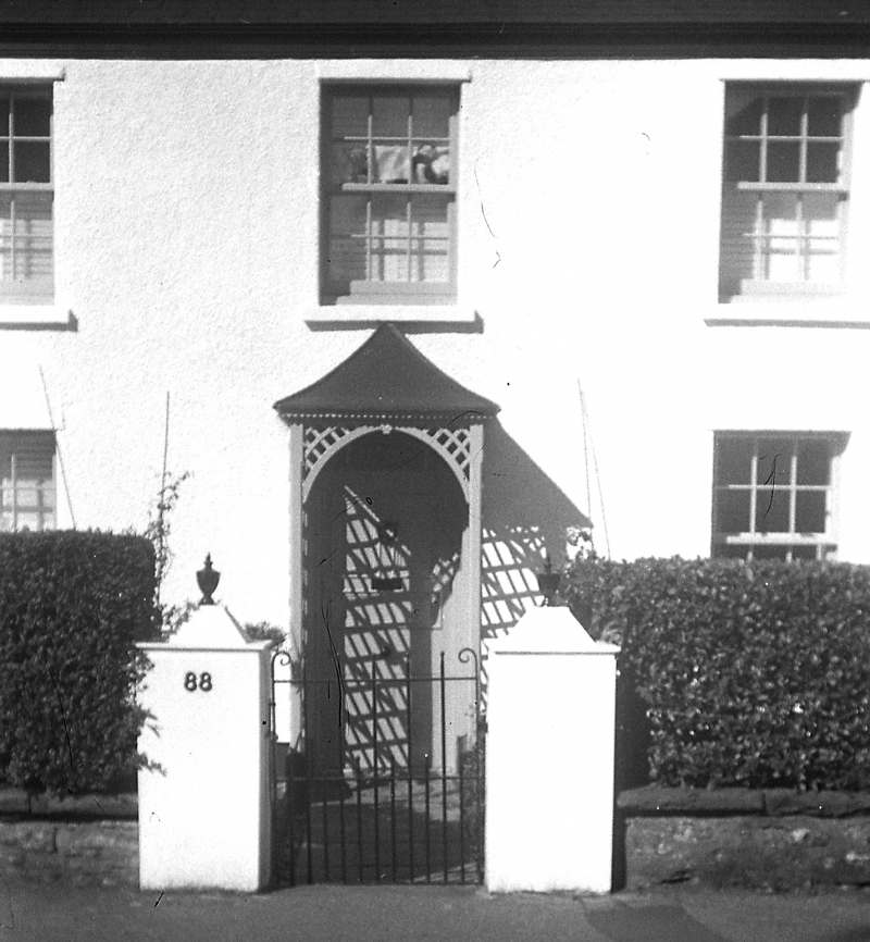
Contemporary with the house at c1800.

Exterior

Rubble dwarf wall with coping, square piers with conical iron caps at either end. Central square gate piers with iron urn finials. Wrought Iron gate.

Reasons for Listing

Included for their group value with No 88 and with Tabernacle Chapel opposite.

External Links

External links are from the relevant listing authority and, where applicable, Wikidata. Wikidata IDs may be related buildings as well as this specific building. If you want to add or update a link, you will need to do so by editing the Wikidata entry.

Recommended Books

Other nearby listed buildings

  • II Bridge House
    Immediately opposite to Tabernacle Chapel and about 300m south-east of the Church of St. Mary.
  • II Tabernacle Chapel
    Immediately opposite to Bridge House and about 300m south-east of the Church of St. Mary.
  • II Church of St. Mary
    In the centre of the Community at the junction of Church Road, Merthyr Road and Penlline Road.
  • II Six Gables
    No 27A: extends south from south return of No 27. On the main road about 100m north of the Church of St. Mary.
  • II The Laurels
    On the main road about 100m north of the Church of St. Mary.
  • II The Pines
    Immediately north of the site of the old parish church and 300m north-east of the present parish church.
  • II Whitchurch War Memorial
    In the garden outside Whitchurch Library.
  • II Whitchurch Free Library
    On the north side of the roundabout at the junction of Penlline Road, Park Road and Velindre Road.

BritishListedBuildings.co.uk is an independent online resource and is not associated with any government department. All government data published here is used under licence. Please do not contact BritishListedBuildings.co.uk for any queries related to any individual listed building, planning permission related to listed buildings or the listing process itself.

British Listed Buildings is a Good Stuff website.