History in Structure

Entrance Piers at the Minffordd Approach to Portmeirion

A Grade II Listed Building in Penrhyndeudraeth, Gwynedd

More Photos »
Approximate Location Map
Large Map »

Coordinates

Latitude: 52.9248 / 52°55'29"N

Longitude: -4.0894 / 4°5'21"W

OS Eastings: 259640

OS Northings: 338419

OS Grid: SH596384

Mapcode National: GBR 5R.MWMD

Mapcode Global: WH55M.4RY4

Plus Code: 9C4QWWF6+W7

Entry Name: Entrance Piers at the Minffordd Approach to Portmeirion

Listing Date: 23 August 2002

Last Amended: 23 August 2002

Grade: II

Source: Cadw

Source ID: 26888

Building Class: Gardens, Parks and Urban Spaces

ID on this website: 300026888

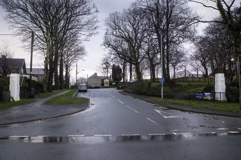
Location: Set back slightly from the main road at its junction with the access road to Portmeirion.

County: Gwynedd

Community: Penrhyndeudraeth

Community: Penrhyndeudraeth

Locality: Portmeirion

Traditional County: Merionethshire

Tagged with: Gatepost

Find accommodation in
Minffordd

History

Portmeirion was designed and laid out by the celebrated architect Sir Clough Williams-Ellis (1883-1978) following his purchase of the estate, then called Aber IĆ¢, in 1926. The village evolved over several decades and was still being added to in the 1970s.

Exterior

Pair of entrance piers; of whitened cement blocks in three diminishing stages and with stopped-chamfered edges; on square plinth bases. Each pier is surmounted by a square vase of reconstituted stone with figurative relief decoration to the sides.

Reasons for Listing

Listed as a pair of C20 entrance piers erected by Sir Clough Williams-Ellis, architect and conservationist, as part of his inspired Portmeirion Village.

External Links

External links are from the relevant listing authority and, where applicable, Wikidata. Wikidata IDs may be related buildings as well as this specific building. If you want to add or update a link, you will need to do so by editing the Wikidata entry.

Recommended Books

Other nearby listed buildings

  • II Railway Lodge at the Ffestiniog Railway Crossing
    To the N of, and below the village, accessed via a narrow lane bounded by rubble walls. The house is set on a levelled site at the SW corner of the crossing; behind a slate stave fence.
  • II Former Lodge to Plas Penrhyn
    On the roadside at the start of the lane leading SW up the hill to Plas Penrhyn.
  • II Rhos House
    On a slightly raised site near the entrance road to Minffordd Quarry near the northern boundary of the comunity.
  • II Minffordd Station
    At the junction between the Ffestiniog and Cambrian railways, between Penrhyndeudraeth and Minffordd village.
  • II Former Women's Institute Hall
    On the N side of the High St (A497) adjacent to Minffordd Railway Station.
  • II Former Stable Range at Plas Newydd
    Located immediately SW of Plas Newydd Farmhouse, adjoining a modern barn to the N.
  • II Casual Ward at Bron-y-Garth Hospital
    Immediately to SW of the main hospital building, at right angles to the A487.
  • II Borthwen
    Overlooking the Traeth Bach towards the SE boundary of the community, to the E of Castle Yard; accessed via a long drive leading E off a lane running parallel with the main Portmeirion access road.

BritishListedBuildings.co.uk is an independent online resource and is not associated with any government department. All government data published here is used under licence. Please do not contact BritishListedBuildings.co.uk for any queries related to any individual listed building, planning permission related to listed buildings or the listing process itself.

British Listed Buildings is a Good Stuff website.