Approximate Location Map
Large Map »
Latitude: 53.2683 / 53°16'5"N
Longitude: -4.2681 / 4°16'5"W
OS Eastings: 248838
OS Northings: 376993
OS Grid: SH488769
Mapcode National: GBR HNT2.5NX
Mapcode Global: WH42V.D3TR
Plus Code: 9C5Q7P9J+8Q
Entry Name: Parc
Listing Date: 12 March 2003
Last Amended: 12 March 2003
Grade: II
Source: Cadw
Source ID: 80974
Building Class: Agriculture and Subsistence
ID on this website: 300080974
Location: Set back, along private trackways, from the W side of Siloam Terrace in the heart of the village of Talwrn.
County: Isle of Anglesey
Town: Llangefni
Community: Llanddyfnan
Community: Llanddyfnan
Locality: Talwrn
Traditional County: Anglesey
Tagged with: Architectural structure
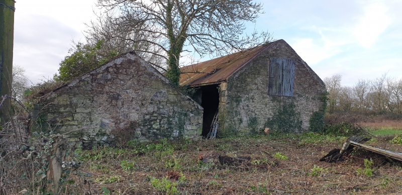
Traditional small holding, latterly of 14 acres(5.7 hectares), and with buildings consistent with this acreage. Probably early nineteenth century. Apparently a small-scale farm, growing a range of green crops and maintaining a small dairy herd (the dairy survives as a semi-ruinous building in front of the main range).
Long range comprising single storeyed cottage with separate enclosed garden to front, flanked by cow-house range to the right, and out-kitchen and store with granary over to the left. Immediately to the rear of the cowhouse range is a substantial haybarn. A stable behind the granary range is a twentieth century addition. Rubble masonry, limewashed throughout; bedded and grouted slate roof to cottage, regular (and later) slates to cowhouse.
Cottage has central doorway flanked by 4-pane sash windows (boarded at time of inspection); gable end stacks, equally sized. Cowhouse range to right has two doorways, flanking a central window. Outkitchen and store to left are a low two storeys: the kitchen has doorway to right, and 4-pane sash window to left, under a single long timber lintel; outbuilding has single doorway in front elevation, and access to the upper granary by external staircase against the gable end; 2 upper windows have glazed upper panes, and slatted lower sections to provide ventilation to granary. Haybarn at rear of cowhouse was formerly of open type, and 3 bays; now the two outer open bays in its front elevation have been blocked with rubble, to form a semi-enclosed barn.
Cottage retains its original layout intact, divided as a principal room with main fireplace, and a secondary heated room. High ceiling over main room may suggest former existence of a croglofft over the secondary room only - the previous existence of a loft is recalled. The secondary room has a fine carved slate fireplace, with simple concentric circles in the lintel, floral motifs in simple lined panels in the side-pieces. The boarded ceiling may also be original. The kitchen retains the remnants of a painted calico ceiling, nailed between the rafters.
Listed as a remarkably intact small-holding or small farmstead, with dwelling and ancillary agricultural buildings forming a coherent unit. Good vernacular character is retained in the layout, constructional detail and finish (the limewashed walls, and bedded slate roofs). The buildings are particularly valuable as retaining the internal arrangement virtually intact.
External links are from the relevant listing authority and, where applicable, Wikidata. Wikidata IDs may be related buildings as well as this specific building. If you want to add or update a link, you will need to do so by editing the Wikidata entry.


Other nearby listed buildings
