Approximate Location Map
Large Map »
Latitude: 52.8287 / 52°49'43"N
Longitude: -3.4187 / 3°25'7"W
OS Eastings: 304509
OS Northings: 326625
OS Grid: SJ045266
Mapcode National: GBR 6M.TXQC
Mapcode Global: WH78S.G589
Plus Code: 9C4RRHHJ+FG
Entry Name: Nant-yr-henglawdd farm range
Listing Date: 23 May 2003
Last Amended: 23 May 2003
Grade: II
Source: Cadw
Source ID: 81054
Building Class: Agriculture and Subsistence
ID on this website: 300081054
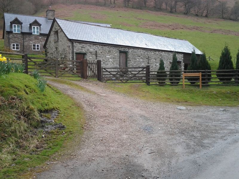
Location: At front of Nant-yr-henglawdd farmhouse, parallel to the road.
County: Powys
Community: Llangynog (LLangynog)
Community: Llangynog
Locality: Cwm Rhiweirth
Traditional County: Montgomeryshire
Tagged with: Architectural structure
Probably early C19, and contemporary with the farmhouse.
A long multi-purpose agricultural range in uncoursed slate masonry, with a six-bay slate roof and a tile ridge, apart from the right (north) bay which has been roofed in metal sheeting. Sited at a lower level than the house and its yard, the range is entered from the east side, facing the road. The range comprises a barn centrally with accommodation for livestock or stabling and a loft, and an open shed.
At front, from left to right, there is a ventilated door, a shuttered loft hatch, a plain boarded door, a ventilation slit, a raised heck door at the head of three corbelled steps, and another ventilation slit. There is one door at the right end. The last bay at the right is open-fronted. Small central opening at rear, loft door in right gable.
Listed as a multi-purpose farm range typical of small upland farms and for group value with Nant-yr-henglawdd farmhouse.
External links are from the relevant listing authority and, where applicable, Wikidata. Wikidata IDs may be related buildings as well as this specific building. If you want to add or update a link, you will need to do so by editing the Wikidata entry.


Other nearby listed buildings
