History in Structure

Inscribed stone pillar at Church of St Michael

A Grade II Listed Building in Talsarnau, Gwynedd

More Photos »
Approximate Location Map
Large Map »

Coordinates

Latitude: 52.8975 / 52°53'51"N

Longitude: -4.0902 / 4°5'24"W

OS Eastings: 259494

OS Northings: 335389

OS Grid: SH594353

Mapcode National: GBR 5R.PGX2

Mapcode Global: WH55T.4FKJ

Plus Code: 9C4QVWX5+2W

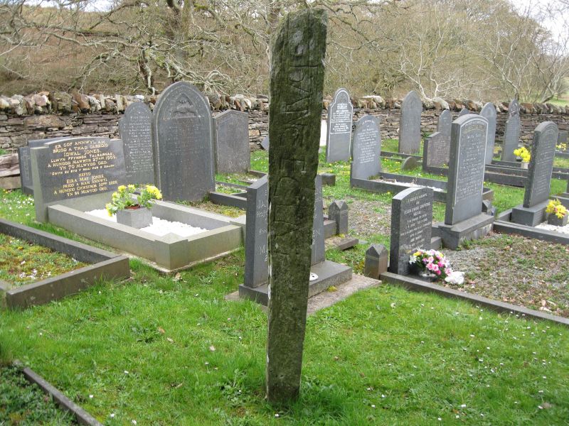
Entry Name: Inscribed stone pillar at Church of St Michael

Listing Date: 30 December 2004

Last Amended: 30 December 2004

Grade: II

Source: Cadw

Source ID: 83452

Building Class: Commemorative

Also known as: Inscribed Stone in Llanfihangel Traethau Churchyard
Inscribed Stone, St Michael's Church, Llanfihangel-y-Traethau

ID on this website: 300083452

Location: Located to WNW of the Church of St Michael

County: Gwynedd

Community: Talsarnau

Community: Talsarnau

Locality: Llanfihangel y Traethau

Traditional County: Merionethshire

Tagged with: Architectural structure Inscribed stone

Find accommodation in
Talsarnau

History

C12 inscribed stone.

Exterior

Tall stone pier, roughly shaped and each of its 4 faces inscribed with a legend which reads:
HOC EST SEPULCHRUM WLEDER MATRIS ODELEV QUI PRIMUS EDIFICAVIT HANC ECCLESIAM IN TEMPORE WINI REGIS

The translation by Nash Williams reads:
'Here is the tomb of Wleder mother of Hoedliw who first built this church in the time of King Owain'.

King Wini (Ewini) is probably Owain Gwynedd, who died in 1170.

Reasons for Listing

Included as a rare C12 inscribed stone pillar.

External Links

External links are from the relevant listing authority and, where applicable, Wikidata. Wikidata IDs may be related buildings as well as this specific building. If you want to add or update a link, you will need to do so by editing the Wikidata entry.

Recommended Books

Other nearby listed buildings

  • II Church of St Michael
    At then end of a country lane leading N and W off the A496 in the village of Ynys.
  • II Lofted cartshed at Tyddyn Eglwys
    Slightly set back from the S side of a country lane which leads W off the A496 in Ynys towards the Church of St Michael; to NNE of the house at Tyddyn Eglwys.
  • II Tyddyn Eglwys
    Set back from the S side of a country lane which leads W off the A496 in Ynys towards the Church of St Michael.
  • II Pont Ty-gwyn gamlas
    Spanning a tributary of the Afon y Glyn and carrying the A496 to Harlech at Ynys.
  • II Ty Gwyn Mawr
    At the N end of the village of Ynys, where the Afon y Glyn meets the Glastraeth estuary.
  • II Bridge to SW of Rhosigor
    Set back from the SW side of the B4573 to SW of Rhosigor
  • II Cornbarn and stable ranges at Rhosigor
    Slightly set back from the NE side of the B4573, to SSW of the house at Rhosigor.
  • II Rhosigor
    In an elevated position, set back from the NE side of the B4573 in the small hamlet of Glan-y-wern.

BritishListedBuildings.co.uk is an independent online resource and is not associated with any government department. All government data published here is used under licence. Please do not contact BritishListedBuildings.co.uk for any queries related to any individual listed building, planning permission related to listed buildings or the listing process itself.

British Listed Buildings is a Good Stuff website.