History in Structure

Dock Basin

A Grade II Listed Building in Connah's Quay, Flintshire

More Photos »
Approximate Location Map
Large Map »

Coordinates

Latitude: 53.2214 / 53°13'17"N

Longitude: -3.0588 / 3°3'31"W

OS Eastings: 329401

OS Northings: 369896

OS Grid: SJ294698

Mapcode National: GBR 73.11GK

Mapcode Global: WH770.Z9L7

Plus Code: 9C5R6WCR+HF

Entry Name: Dock Basin

Listing Date: 26 August 2005

Last Amended: 26 August 2005

Grade: II

Source: Cadw

Source ID: 85255

ID on this website: 300085255

Location: Dock Road leads from the W end of the High Street towards the quayside, the dock basin off its NW side on a sharp bend.

County: Flintshire

Town: Deeside

Community: Connah's Quay (Cei Connah)

Community: Connah's Quay

Built-Up Area: Connah's Quay

Traditional County: Flintshire

Tagged with: Dock

Find accommodation in
Hawarden

History

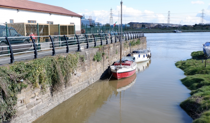
The dock basin was built in the early C19 and is shown on the Tithe map of 1839. It was originally used for exporting coal, the quay subsequently attracting ship-builders such as Ferguson, McCallum & Baird. On the Ordnance Survey of 1870, cranes and railways are marked along its sides. The style of the masonry suggests it was re-faced in the late C19.

Exterior

A large 3-sided dock basin, the 4th side open to the Dee Estuary. The 3 sides are lined by large blocks of snecked stone with flat stone copings, continuing as flagstone paving to the S side.

Reasons for Listing

Listed for its special interest as a little-altered estuarine dock basin, reflecting a growth in industrial exports in the C19. Group value with the Old Quay House Inn and its former barn.

External Links

External links are from the relevant listing authority and, where applicable, Wikidata. Wikidata IDs may be related buildings as well as this specific building. If you want to add or update a link, you will need to do so by editing the Wikidata entry.

Recommended Books

Other nearby listed buildings

  • II Old Quay House Inn
    Located off the NW side of Dock Road on a sharp bend, facing the Dock Basin.
  • II Former Barn, Old Quay House Inn
    Located to the rear of and at right angles to the Old Quay House Inn. A 2nd parallel outbuilding to the W, now converted to accommodation, formed the 3rd side to a small yard.
  • II Church of St Mark
    Located on the S side of the main road, on the W side of Connah's Quay.
  • II The Ship Public House
    Fronting the S side of the High Street.
  • II Lychgate at Church of St Mark
    Located on the S side of the main road, on the W side of Connah's Quay, and fronting a lay-by. The lychgate is flanked by churchyard boundary walls which were rebuilt when the road was widened in the
  • II The Vicarage
    Located to the rear of the Church of St Mark and reached by a driveway to the E of the churchyard.
  • II Former Stable Block & attached boundary walls
    Located to the rear of the vicarage, the ranges and boundary walls forming a rear courtyard.
  • II War Memorial
    Set back from the road in a paved area, adjacent to the Wepre Bridge.

BritishListedBuildings.co.uk is an independent online resource and is not associated with any government department. All government data published here is used under licence. Please do not contact BritishListedBuildings.co.uk for any queries related to any individual listed building, planning permission related to listed buildings or the listing process itself.

British Listed Buildings is a Good Stuff website.