Latitude: 53.2212 / 53°13'16"N
Longitude: -3.0598 / 3°3'35"W
OS Eastings: 329337
OS Northings: 369879
OS Grid: SJ293698
Mapcode National: GBR 73.11UF
Mapcode Global: WH770.Z94C
Plus Code: 9C5R6WCR+F3
Entry Name: Former Barn, Old Quay House Inn
Listing Date: 26 August 2005
Last Amended: 26 August 2005
Grade: II
Source: Cadw
Source ID: 85257
ID on this website: 300085257
Location: Located to the rear of and at right angles to the Old Quay House Inn. A 2nd parallel outbuilding to the W, now converted to accommodation, formed the 3rd side to a small yard.
County: Flintshire
Town: Deeside
Community: Connah's Quay (Cei Connah)
Community: Connah's Quay
Built-Up Area: Connah's Quay
Traditional County: Flintshire
Tagged with: Barn
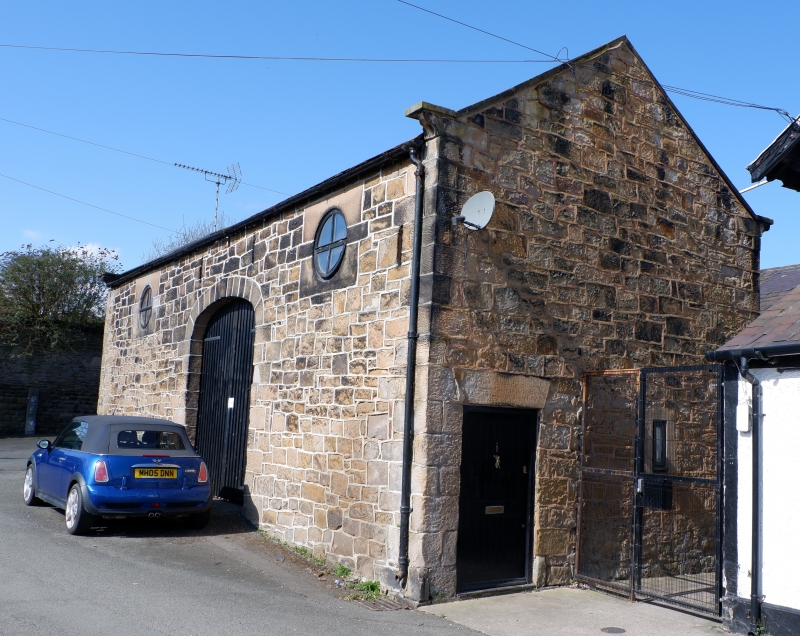
Old Quay House, dated 1777, was originally a farm. It had been converted to an Inn by the late C19 and was closely associated with the docks. The Inn was rebuilt in the early C20, the old datestone reset into the front wall. This barn is probably contemporary with the original farmhouse (1777) and is shown on the Tithe map of 1839. It is now partly converted to accommodation.
Symmetrical 3-bay lofted range constructed of coursed blocks of yellow sandstone under an old slate roof. Dressed sandstone quoins with moulded kneelers and raised stone copings. Wide central entrance with elliptical-arched head, of dressed sandstone. This is flanked by circular pitching eyes to loft, each set within a square ashlar panel. Ventilation slits above entrance and to each side. N gable end has boarded door to L under a wedge lintel; no openings to S gable end. Rear has opposing elliptical-arched opening to through-passage, 2 openings to R with wedge lintels, detail not seen. Two added timber dormers to loft, probably late C20; skylight.
Interior not seen at time of survey.
Listed as a good Georgian farm building retaining much of its architectural character and detail, and for group value with Old Quay House Inn and the dock basin which it overlooks.
External links are from the relevant listing authority and, where applicable, Wikidata. Wikidata IDs may be related buildings as well as this specific building. If you want to add or update a link, you will need to do so by editing the Wikidata entry.


Other nearby listed buildings