Approximate Location Map
Large Map »
Latitude: 52.3367 / 52°20'12"N
Longitude: -2.2923 / 2°17'32"W
OS Eastings: 380180
OS Northings: 270998
OS Grid: SO801709
Mapcode National: GBR 0BZ.H85
Mapcode Global: VH920.7J0J
Plus Code: 9C4V8PP5+M3
Entry Name: Boundary Wall to Churchyard
Listing Date: 11 October 1991
Grade: II
Source: Historic England
Source ID: 1217955
English Heritage Legacy ID: 393379
ID on this website: 101217955
Location: St Bartholomew's Church, Areley Kings, Wyre Forest, Worcestershire, DY13
County: Worcestershire
District: Wyre Forest
Civil Parish: Stourport-on-Severn
Built-Up Area: Stourport-on-Severn
Traditional County: Worcestershire
Lieutenancy Area (Ceremonial County): Worcestershire
Church of England Parish: Areley Kings
Church of England Diocese: Worcester
Tagged with: Wall
STOURPORT ON SEVERN
SO8070NW RECTORY LANE, Areley Kings
589-1/11/90 (North West side)
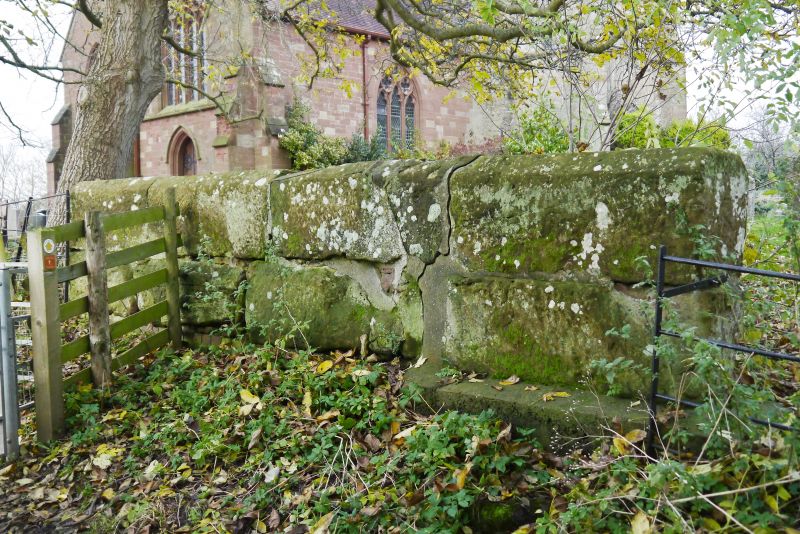
Boundary Wall to Churchyard
GV II
Length of boundary wall to west of churchyard. 1701. Erected
as a memorial to Sir Harry Coningsby. Stone with chamfered
copings. Fragmentary inscription survives in tall letters on
the side, Lithologem a o, apparently when complete, reading:
Lithologem quare Reponitur Sir Harry.
Listing NGR: SO8018070998
External links are from the relevant listing authority and, where applicable, Wikidata. Wikidata IDs may be related buildings as well as this specific building. If you want to add or update a link, you will need to do so by editing the Wikidata entry.


Other nearby listed buildings
