Approximate Location Map
Large Map »
Latitude: 51.809 / 51°48'32"N
Longitude: -1.6365 / 1°38'11"W
OS Eastings: 425159
OS Northings: 212328
OS Grid: SP251123
Mapcode National: GBR 5SW.F31
Mapcode Global: VHBZS.LS7K
Plus Code: 9C3WR957+JC
Entry Name: Falkland Hall
Listing Date: 12 September 1955
Grade: II*
Source: Historic England
Source ID: 1224323
English Heritage Legacy ID: 420350
ID on this website: 101224323
Location: Burford, West Oxfordshire, OX18
County: Oxfordshire
District: West Oxfordshire
Civil Parish: Burford
Built-Up Area: Burford
Traditional County: Oxfordshire
Lieutenancy Area (Ceremonial County): Oxfordshire
Church of England Parish: Burford
Church of England Diocese: Oxford
Tagged with: House
BURFORD AND UPTON HIGH STREET
AND SIGNET (West Side)
SP2512 (Enlargement) Falkland Hall
7/122
12.9.55
GV II*
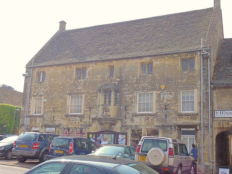
Town house. c.1578, windows altered C18, altered again mid-C20. Coursed
and squared rubble, partly on a moulded plinth; Cotswold stone roof, coped
verges, miniscule ashlar end chimnies. The plan is lost due to C20
alterations, but Buckler's view of 1821 shews a fine central group of
twisted chimnies and a blank area in the centre of the ground floor which
may have been an entrance and hints therefore at a lobby entry. Tall-3
storey house with attic lit from end gables; no gables to front. 2:1:2
windows to front, the central feature is a stone 1st floor oriel bay with
1:2:1 hollow-chamfered 2-light mullions, finial, moulded cornice, plinth
and corbel. Hollow-chamfered 2-light mullion windows to 2nd floor (single
light in centre); C18 glazing-bar sashes on 1st floor in raised flat
surrounds with cock-beads and keys, outer 12-pane, inner 16-pane, on
ground floor, 2" pairs of similar (post 1821) windows flanking the central
space below the oriel; outer doorways with similar architraves. Moulded
string over ground floor raised up to plinth of oriel (this string is
interrupted by ground floor window and door architraves. The house
extends into Priory Lane (q.v. Nos 1 and 2 Priory Lane). North gable has
small lights, South gable has remains of a large 1st floor window. Rear
now shorn of its fine stair-turret, the resemblance of this turret to
seigneurial types in the Loire region of France suggests that it may have
also acted as a principal entrance - but given that access to the rear
would have been easier via Priory Lane, this is most unlikely.
Interior: ground floor ceiling removed for galleried shop-hall.
Listing NGR: SP2515912328
External links are from the relevant listing authority and, where applicable, Wikidata. Wikidata IDs may be related buildings as well as this specific building. If you want to add or update a link, you will need to do so by editing the Wikidata entry.


Other nearby listed buildings
