Approximate Location Map
Large Map »
Latitude: 52.2436 / 52°14'36"N
Longitude: 0.7145 / 0°42'52"E
OS Eastings: 585425
OS Northings: 264072
OS Grid: TL854640
Mapcode National: GBR QF0.7GX
Mapcode Global: VHKD4.BVLY
Plus Code: 9F426PV7+CR
Entry Name: 10, Hatter Street
Listing Date: 12 July 1972
Last Amended: 30 October 1997
Grade: II
Source: Historic England
Source ID: 1246719
English Heritage Legacy ID: 466896
ID on this website: 101246719
Location: Bury St Edmunds, West Suffolk, IP33
County: Suffolk
District: West Suffolk
Civil Parish: Bury St Edmunds
Built-Up Area: Bury St Edmunds
Traditional County: Suffolk
Lieutenancy Area (Ceremonial County): Suffolk
Church of England Parish: Bury St Edmunds St Mary
Church of England Diocese: St.Edmundsbury and Ipswich
Tagged with: Building
BURY ST EDMUNDS
TL8564SW HATTER STREET
639-1/14/421 (East side)
12/07/72 No.10
(Formerly Listed as:
HATTER STREET
(East side)
Nos.9, 9A, 10 AND 10A)
GV II
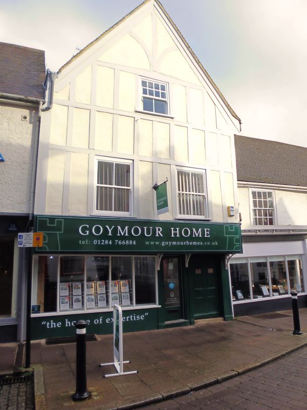
House, now shop and printing office. C16 and early C17 with
later alterations. Timber-framed and rendered, with applied
mock timbering to the upper storey above a jetty. Plaintiled
roof. Cross-wing form with a wide, high gable facing the
street. A rear range is linked to the front by a large
internal red brick chimney-stack with attached shafts.
EXTERIOR: 2 storeys, attic and cellar: 2 window range: sashes
with a single vertical glazing-bar in flush cased frames. A
C20 shop front to the ground storey.
INTERIOR: the 2-bay front range has most timbers hidden and
has been raised. The rear range, also in 2 bays, has identical
cross-beams exposed on the ground and 1st storey ceilings,
with a small chamfer and scroll stops.
On the 1st storey, sparse widely-spaced joists exposed, and
some studding with arched braces at the corners. The main
tie-beam is morticed into the sides of the main posts well
below wall-plate level, giving a large attic area (cf. No.40
Crown Street, qv). Beside the chimney-stack the remains of a
Jacobean stair with bulbous balusters. Roof timbers covered.
Listing NGR: TL8542564072
External links are from the relevant listing authority and, where applicable, Wikidata. Wikidata IDs may be related buildings as well as this specific building. If you want to add or update a link, you will need to do so by editing the Wikidata entry.


Other nearby listed buildings
