Approximate Location Map
Large Map »
Latitude: 53.7951 / 53°47'42"N
Longitude: -1.5368 / 1°32'12"W
OS Eastings: 430612
OS Northings: 433295
OS Grid: SE306332
Mapcode National: GBR BLM.GC
Mapcode Global: WHC9D.CWG0
Plus Code: 9C5WQFW7+27
Entry Name: Boundary Wall to West of Parish Church of St Peter with South West Gateway
Listing Date: 8 May 1974
Last Amended: 11 September 1996
Grade: II
Source: Historic England
Source ID: 1255561
English Heritage Legacy ID: 465874
ID on this website: 101255561
Location: Steander, Leeds, West Yorkshire, LS2
County: Leeds
Electoral Ward/Division: City and Hunslet
Parish: Non Civil Parish
Built-Up Area: Leeds
Traditional County: Yorkshire
Lieutenancy Area (Ceremonial County): West Yorkshire
Church of England Parish: Leeds City
Church of England Diocese: Leeds
Tagged with: Wall
LEEDS
SE3033SE CHURCH ROW
714-1/79/97 (East side)
08/05/74 Boundary wall to west of Parish
Church of St Peter, with south-west
gateway
(Formerly Listed as:
KIRKGATE
(South side (off))
Gatepiers NW and SW of St Peter's
Church and churchyard wall north and
west)
GV II
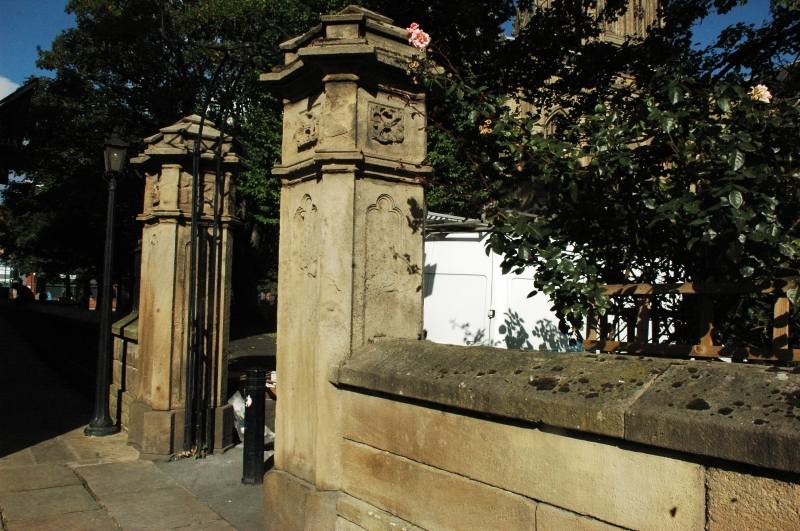
Boundary wall to churchyard with gate piers and overthrow with
lantern bracket. 1841. Gritstone, coursed and squared and cut
to ashlar finish; cast-iron railings and overthrow. Approx 65m
long and 1m high, rising to 1.5m, from north to south end;
extending from west pier of NW gateway to churchyard along
Church Row.
2 courses of ashlar at north end, raised with coursed squared
blocks to accommodate drop in ground level; gabled coping with
seating for missing railings for most of length, but a short
length of railing with arrow-head finials to bars survives (or
replaced) to left of gateway.
Gate piers approx 3m high, square section, chamfered plinth
and panelled sides, cornices with quatrefoil panels, 2-tier
pyramidal caps.
Overthrow has paired square-section bars linked by palmette
motif at cornice height, scrolled at each side of lantern
bracket.
HISTORICAL NOTE: now opening into the end of Kirk Ings Yard
and little used, this was one of the main entrances into the
precinct of the old Church of St Peter and continued in use
after the rebuild of 1839-41.
Before the establishment of the present line of The Calls in
c1830 to the south, the medieval routeway from the manor house
and Briggate to the east was via this lane and the churchyard
to Timble Bridge.
(Thoresby Society and Leeds City Library: Giles map of Leeds,
1815 (Reprinted): 1987-).
Listing NGR: SE3061333294
External links are from the relevant listing authority and, where applicable, Wikidata. Wikidata IDs may be related buildings as well as this specific building. If you want to add or update a link, you will need to do so by editing the Wikidata entry.


Other nearby listed buildings
