Approximate Location Map
Large Map »
Latitude: 53.795 / 53°47'41"N
Longitude: -1.5371 / 1°32'13"W
OS Eastings: 430587
OS Northings: 433286
OS Grid: SE305332
Mapcode National: GBR BLM.CD
Mapcode Global: WHC9D.CW82
Plus Code: 9C5WQFV7+X4
Entry Name: 19, High Court Lane
Listing Date: 21 February 1992
Grade: II
Source: Historic England
Source ID: 1255925
English Heritage Legacy ID: 465454
ID on this website: 101255925
Location: Steander, Leeds, West Yorkshire, LS2
County: Leeds
Electoral Ward/Division: City and Hunslet
Parish: Non Civil Parish
Built-Up Area: Leeds
Traditional County: Yorkshire
Lieutenancy Area (Ceremonial County): West Yorkshire
Church of England Parish: Leeds City
Church of England Diocese: Leeds
Tagged with: Building
LEEDS
SE3033SE HIGH COURT LANE
714-1/79/206 (East side)
21/02/92 No.19
GV II
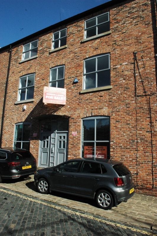
House, now warehouse. Late C18/early C19 with late C19
alterations. Rendered brick, grey slate roof with large stack
to right.
3 storeys, 3 first-floor windows: 4-pane sashes, slightly
cambered arched heads, narrower central window, smaller
windows just below eaves to 2nd floor. Central door with
overlight, flanking canted bay windows. Rear: stair window
left, 12-pane sash to top story, right, C20 frame below. No.17
(qv), on north side, probably part of the house which in 1847
had bow windows (OS map).
INTERIOR: not inspected.
HISTORICAL NOTE: the site was an important one, being just
west of the parish church and close to the river wharves and
occupied since at least the early C18 (Cossins map). The
group, with Nos 15, 17 (qqv) & 21 (not included), was possibly
built as a complex of merchant's house, workers' housing and
warehouse in the later C18. The National School (1812) stood
just to the east, across the school yard, suggesting that this
house might have been associated with it. The area declined as
a residential quarter during the C19 and particularly after
the construction of the railway viaduct in 1869. A lodging
house in 1902 (Insurance map), by which time the bay windows
had been built.
Listing NGR: SE3058733286
External links are from the relevant listing authority and, where applicable, Wikidata. Wikidata IDs may be related buildings as well as this specific building. If you want to add or update a link, you will need to do so by editing the Wikidata entry.


Other nearby listed buildings
