Latitude: 53.7947 / 53°47'40"N
Longitude: -1.5382 / 1°32'17"W
OS Eastings: 430516
OS Northings: 433255
OS Grid: SE305332
Mapcode National: GBR BLM.4H
Mapcode Global: WHC9D.BWR8
Plus Code: 9C5WQFV6+VP
Entry Name: Fletland Mills
Listing Date: 11 September 1996
Grade: II
Source: Historic England
Source ID: 1255929
English Heritage Legacy ID: 465458
ID on this website: 101255929
Location: Steander, Leeds, West Yorkshire, LS2
County: Leeds
Electoral Ward/Division: City and Hunslet
Parish: Non Civil Parish
Built-Up Area: Leeds
Traditional County: Yorkshire
Lieutenancy Area (Ceremonial County): West Yorkshire
Church of England Parish: Leeds City
Church of England Diocese: Leeds
LEEDS
SE3033SE THE CALLS 714-1/79/382 (South side) Nos.40 AND 42 Fletland Mills
II
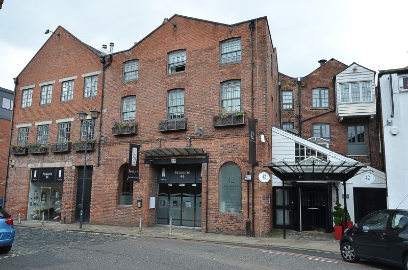
Warehouses, mill and office premises, now hotel and restaurant. Early C19, enlarged mid C19, converted c1990. Brick, English and random bond, the east and west ranges dark red, irregularly shaped on east, the central range orange; stone details; slate roofs. 3 parallel 4-storey ranges, gables to river, the west range having a 2-storey office range at the north (street) end. Street frontage: office block has 2 first-floor windows and inserted doorway, right; left return, to yard: blocked cart entrance, glazing-bar sash window above, in flush wood frame with cambered rubbed-brick arch and stone sill; remaining windows altered. Main ranges: central block open on ground floor, left block ground floor obscured by added boiler house block, right range by office block. Segmental-arched windows, wooden hoist cover to top floor, centre; external stack to centre of right gable. River frontage: left (west) range; blocked loading door with cambered arch and hinge stones to each floor, right; 5 tiers of small windows to left. Central range: central loading doors, remains of hoist cover, flanked by large multi-pane windows, all with segmental arches. Right range: Central wide, low elliptical-arched opening to each floor, key and top hinge-stones; flanking taller segmental-arched windows. INTERIOR: ground floor only examined in part; west range, 5 cylindrical columns support cross beams of timber clasping a cast-iron beam, closely-set joists on edge; the outer wall rebuilt outside original line. Central range, re-used cylindrical cast-iron pillars. East range, an elliptical archway, stone details as river front, now opens into central range; steel girders support upper floor. The central range is a mid C19 infill of the yard and wharf area between the earlier warehouses. The wharf site is early C18 at least; there was a jetty at the end of Alderman Cookson's garden shown on the 1725 map. By 1770 the east side was built up; by 1815 two parallel ranges flanked the wharf which stood at the end of the Calls and the south end of a narrow lane which became Wharf Street. By 1831 Wharf Street was built up entirely and by 1847 the site of the office range
was occupied. The central range was built between 1866 and 1887. The building was the Palmer Bros mill by the 1850s and belonged to Wright Bros, corn millers in 1887. (Cossins, J: A New and Exact plan of the town of Leeds: 1725-; Jefferys, T: A plan of Leeds: 1770-; Netlam and Frances Giles: Plan of the town of Leeds and its Environs: 1815-; Fowler, C: Plan of the town of Leeds: 1831-; Captain Tucker, surveyor: OS Map, Scale 5 feet : 1 inch: 1850-; Brierley, W: Map of the town of Leeds: 1866-).
Listing NGR: SE3051633255
External links are from the relevant listing authority and, where applicable, Wikidata. Wikidata IDs may be related buildings as well as this specific building. If you want to add or update a link, you will need to do so by editing the Wikidata entry.


Other nearby listed buildings