Approximate Location Map
Large Map »
Latitude: 53.7957 / 53°47'44"N
Longitude: -1.5565 / 1°33'23"W
OS Eastings: 429314
OS Northings: 433358
OS Grid: SE293333
Mapcode National: GBR BGM.74
Mapcode Global: WHC9D.2V3H
Plus Code: 9C5WQCWV+7C
Entry Name: Truck Lifting Tower Aireside Centre
Listing Date: 10 August 1983
Last Amended: 11 September 1996
Grade: II
Source: Historic England
Source ID: 1255695
English Heritage Legacy ID: 465730
Also known as: Truck Lifting Tower
ID on this website: 101255695
Location: Granary Wharf, Leeds, West Yorkshire, LS1
County: Leeds
Electoral Ward/Division: City and Hunslet
Parish: Non Civil Parish
Built-Up Area: Leeds
Traditional County: Yorkshire
Lieutenancy Area (Ceremonial County): West Yorkshire
Church of England Parish: Leeds St George
Church of England Diocese: Leeds
Tagged with: Building
LEEDS
SE2933 WELLINGTON STREET
714-1/35/435 (South side (off))
10/08/83 Truck lifting tower, Aireside Centre
(Formerly Listed as:
WHITEHALL ROAD
Truck Lifting Tower, Aireside Centre)
II
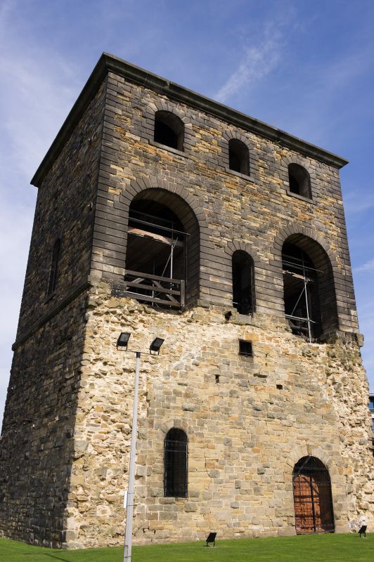
Truck lifting tower. Before 1847. Snecked stone, a mixture of
grey gritstone and softer yellow sandstone, with rusticated
ashlar dressings, string course and cornice, cast-iron window
frames, plaques and details. Roof not visible over parapet.
North side: low level entrance, 2 large arches in outer bays
flanking small central doorway with oculus above, the large
arches have a plaque above: 'TO LIFT 20 TONS', the left also
has a smaller plaque above: 'L&NWRL-Y/2245'. Wide arched
windows in outer bays of 2 storeys above, narrow central
windows. 1st-floor windows deeper than 2nd-floor. Fragmentary
cast-iron small-pane window frames.
South side: high level entrance. Viaduct abutment to ground
floor demolished but the scar of demolished walling is clear.
Wide archway to right, a narrow arched opening left, a square
cast-iron flue opening top centre. 2 large arches to 1st floor
flanking central arched doorway. 3 bays as north side on 2nd
storey. Single arched windows on 1st floors of east and west
sides; the W side has 2 tethering rings low down and the E
side has 3 pairs of round tie-bar plates.
INTERIOR: remains of timber flooring and framework of winch
gear in upper floors.
This building is important as a surviving remnant, with the
river and canal viaduct (qv), of the large Great Northern
Railway complex which occupied the entire area between
Wellington Street and Whitehall Road. Two such towers, either
side of the viaduct, enabled trucks to be lifted from the
low-level Great Northern Goods Station and sidings to the
high-level passenger line on the viaduct arches.
(Fraser, D: A History of Modern Leeds: 1980-: 135).
Listing NGR: SE2931433358
External links are from the relevant listing authority and, where applicable, Wikidata. Wikidata IDs may be related buildings as well as this specific building. If you want to add or update a link, you will need to do so by editing the Wikidata entry.


Other nearby listed buildings
