Latitude: 53.8231 / 53°49'23"N
Longitude: -1.6618 / 1°39'42"W
OS Eastings: 422363
OS Northings: 436369
OS Grid: SE223363
Mapcode National: GBR JSV7.18
Mapcode Global: WHC9B.F5XG
Plus Code: 9C5WR8FQ+67
Entry Name: 166 and 168, Town Street
Listing Date: 5 August 1976
Grade: II
Source: Historic England
Source ID: 1255823
English Heritage Legacy ID: 465628
ID on this website: 101255823
Location: Rodley, Leeds, West Yorkshire, LS13
County: Leeds
Electoral Ward/Division: Calverley and Farsley
Parish: Non Civil Parish
Built-Up Area: Leeds
Traditional County: Yorkshire
Lieutenancy Area (Ceremonial County): West Yorkshire
Church of England Parish: Bramley St Peter
Church of England Diocese: Leeds
Tagged with: Building
LEEDS
SE2236 TOWN STREET, Rodley
714-1/16/1047 (North side)
05/08/76 Nos.166 AND 168
GV II
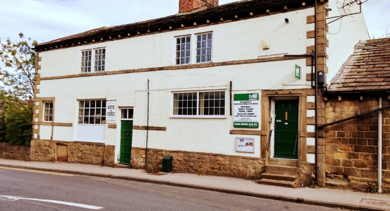
Possibly offices and warehouse, now shops. Early C18;
extensive C20 alterations. Rendered brick and stone over
coursed rubble foundations, stone slate roof.
A tall 2-storey, 2-bay building over a basement, the N wall on
the edge of the Leeds and Liverpool Canal. Stone quoins.
Inserted shop entrance with overlight centre, moulded jambs
and lintel to doorway far right and to window, possibly former
doorway, far left. Large opening left of centre, now window;
C20 window right. Projecting band at former window-sill level
to raised ground and to 1st floor; 2 square windows with C20
small-pane frames to 1st floor. Gutter brackets. Large central
stack built of hand-made bricks straddles ridge. Rear: ground
floor obscured by trees; a small 4-pane sash, a 3-light
mullioned window, and a large doorway with C20 glazing to
upper storey.
INTERIOR: not inspected.
Although altered this remains an unusual form of building; the
canal-side site and proportions, with possible loading door to
canal and high ground floor for loading waggons on the
roadside, suggest that it was an early Canal Company building.
Listing NGR: SE2236336369
External links are from the relevant listing authority and, where applicable, Wikidata. Wikidata IDs may be related buildings as well as this specific building. If you want to add or update a link, you will need to do so by editing the Wikidata entry.


Other nearby listed buildings