Latitude: 53.8172 / 53°49'2"N
Longitude: -1.5632 / 1°33'47"W
OS Eastings: 428852
OS Northings: 435751
OS Grid: SE288357
Mapcode National: GBR BDC.SD
Mapcode Global: WHC9C.Y9RZ
Plus Code: 9C5WRC8P+VP
Entry Name: Grosvenor House with Terrace Walls
Listing Date: 5 August 1976
Last Amended: 11 September 1996
Grade: II
Source: Historic England
Source ID: 1256128
English Heritage Legacy ID: 465249
ID on this website: 101256128
Location: Woodhouse Cliff, Leeds, West Yorkshire, LS6
County: Leeds
Electoral Ward/Division: Headingley
Parish: Non Civil Parish
Built-Up Area: Leeds
Traditional County: Yorkshire
Lieutenancy Area (Ceremonial County): West Yorkshire
Church of England Parish: Woodhouse and Wrangthorn
Church of England Diocese: Leeds
Tagged with: House
LEEDS
SE2835NE GROSVENOR MOUNT, Headingley
714-1/65/746 (South side)
05/08/76 No.2
Grosvenor House with terrace walls
(Formerly Listed as:
GROSVENOR MOUNT, Headingley
(South side)
No.2
Grosvenor House, including wall
immediately to W along Grosvenor
Road)
GV II
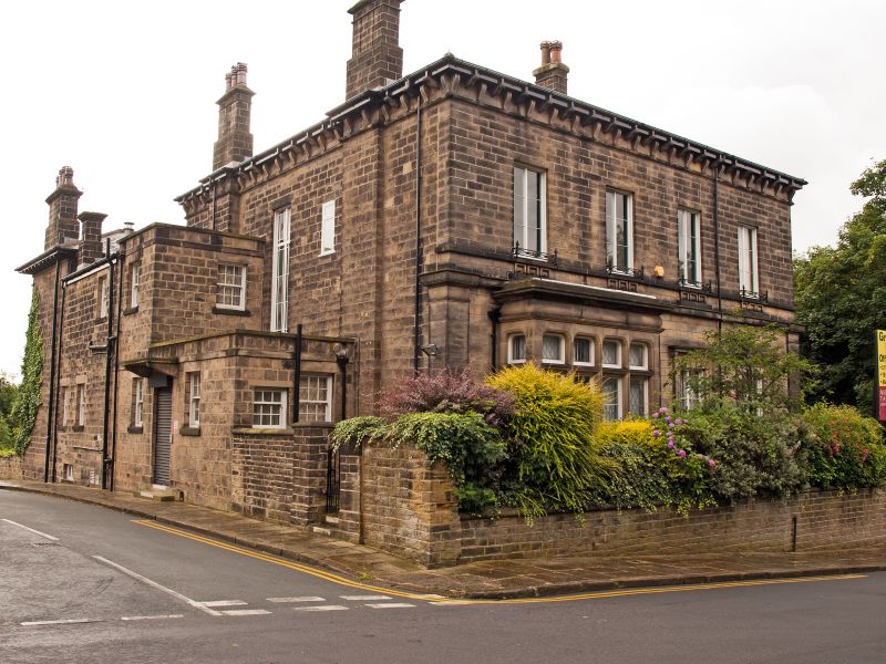
House, now offices, and terrace wall. Mid C19. Converted and
restored c1993. Ashlar, slate hipped roof. 2 storeys with
basement, 3 windows. Classical style with Greek motifs.
S front: central rusticated doorway with porch, the
entablature supported on fluted columns with carved scrolls
and acanthus to capitals. Tall casement windows, (boarded), in
moulded and rusticated architraves with cornice hoods on
brackets; 1st floor plain with iron balconettes and aprons
with Greek key pattern in relief. Rusticated angle pilasters
to 1st-floor level, string course, stone console brackets to
eaves.
Left return: 4 windows wide, large 4-light bay window with
pulvinated frieze and cornice to ground floor. Right return:
basement storey and raised ground floor with stone balcony on
carved console brackets far left; ironwork as front.
INTERIOR: not inspected.
SUBSIDIARY FEATURES: terrace wall and steps on S side: links
to the roadside boundary wall, Grosvenor Road (qv) and extends
approx 20m to the SE corner of the house. Coursed stone with
ashlar, balustrade repaired late C20; a flight of stone steps
with low flanking walls and square ashlar terminals at the W
end.
The house was built on the edge of a sandstone quarry shown on
the 1850 OS map; it is marked as a vicarage on a later
edition.
Listing NGR: SE2885235751
External links are from the relevant listing authority and, where applicable, Wikidata. Wikidata IDs may be related buildings as well as this specific building. If you want to add or update a link, you will need to do so by editing the Wikidata entry.


Other nearby listed buildings