Approximate Location Map
Large Map »
Latitude: 53.8175 / 53°49'3"N
Longitude: -1.5643 / 1°33'51"W
OS Eastings: 428782
OS Northings: 435784
OS Grid: SE287357
Mapcode National: GBR BDC.K9
Mapcode Global: WHC9C.Y98R
Plus Code: 9C5WRC9P+27
Entry Name: Boundary Wall with Gate Piers and Gates to Spring Hill and Elmfield
Listing Date: 11 September 1996
Grade: II
Source: Historic England
Source ID: 1375313
English Heritage Legacy ID: 466208
ID on this website: 101375313
Location: Woodhouse Cliff, Leeds, West Yorkshire, LS6
County: Leeds
Electoral Ward/Division: Headingley
Parish: Non Civil Parish
Built-Up Area: Leeds
Traditional County: Yorkshire
Lieutenancy Area (Ceremonial County): West Yorkshire
Church of England Parish: Woodhouse and Wrangthorn
Church of England Diocese: Leeds
Tagged with: Wall
LEEDS
SE2835NE CUMBERLAND ROAD, Headingley
714-1/65/741 (East side)
Boundary wall with gate piers and
gates to Spring Hill and Elmfield
GV II
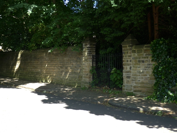
Boundary wall with 3 gateways and 2 pairs of gates. Mid C19.
Coursed gritstone walling, wrought-iron gates.
The walling along the road side extends approx 100m as the
garden wall to Spring Hill (qv), it is approx 3m high and
steps up with the hill slope, the coping is rounded and part
of the wall close to the house has been lowered; at the N end
it returns eastwards to link with the former coach house (qv)
to rear of Spring Hill, approx 15m. At the S end the 2 drives
to Elmfield (qv) and Spring Hill are also flanked by lower
walling for approx 20m.
Gateways: at the N end of the roadside wall the entrance to
the rear yard of Spring Hill is flanked by walling with
stepped ashlar pyramid capstones; at the S end of the roadside
wall the left gateway has similar piers and a pair of gates
with bars, dog bars and roundels to lock rail. The right
gateway is earlier in style, it has fine monolithic square
piers with deep cornice and shallow pyramid capstones and
paired gates with 'X' braces below the lock rail, 'O' above
and depressed top rail with leaf finials to bars.
The low flanking walls have chamfered ashlar coping and a
short stretch of railing in similar style, to right the wall
is approx 2m high with gabled coping.
The arrangement of walling and driveways suggests that the
grounds of Elmfield originally extended to the road edge and
were sold off as development for Spring Hill.
Included for group value with Spring Hill, No.14 (qv) and Nos
12 & 13 Elmfield (qv).
Listing NGR: SE2878235784
External links are from the relevant listing authority and, where applicable, Wikidata. Wikidata IDs may be related buildings as well as this specific building. If you want to add or update a link, you will need to do so by editing the Wikidata entry.


Other nearby listed buildings
