Latitude: 51.0609 / 51°3'39"N
Longitude: -1.7966 / 1°47'47"W
OS Eastings: 414353
OS Northings: 129080
OS Grid: SU143290
Mapcode National: GBR 51F.GLT
Mapcode Global: FRA 7639.ZWY
Plus Code: 9C3W3663+99
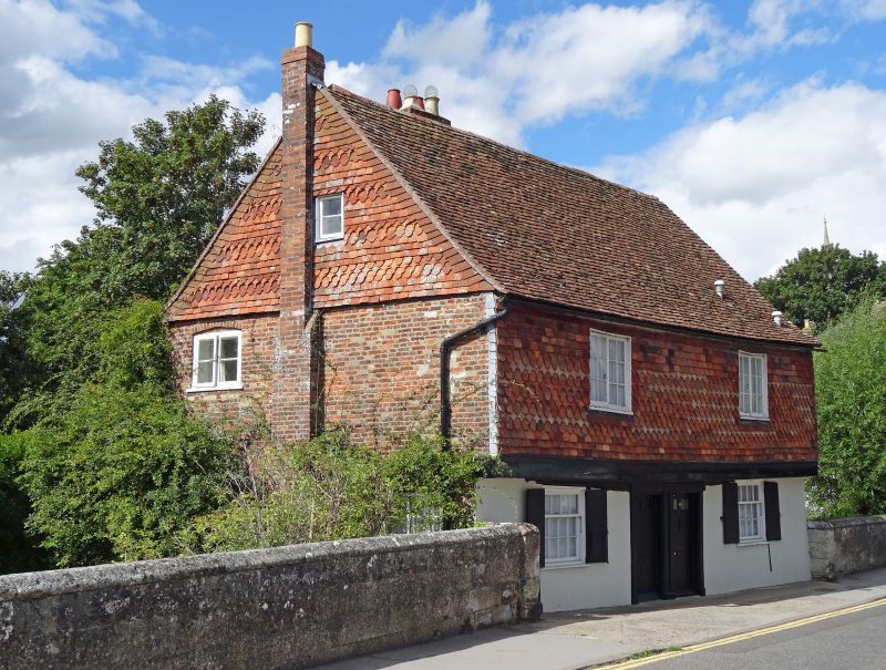
Entry Name: 16 and 18, St Nicholas's Road
Listing Date: 28 February 1952
Grade: II*
Source: Historic England
Source ID: 1259075
English Heritage Legacy ID: 446168
ID on this website: 101259075
Location: The Close, Wiltshire, SP1
County: Wiltshire
Civil Parish: Salisbury
Built-Up Area: Salisbury
Traditional County: Wiltshire
Lieutenancy Area (Ceremonial County): Wiltshire
Tagged with: Building
ST NICHOLAS'S ROAD 1. 1594 (West Side) Nos 16 & 18 SU 1429 SW 5/351 28.2.52. II* GV 2. C16 or earlier origin altered C17 and C18. 3 storey and attic facing river. Brick with tile hung gable ends and 1st floor probably on timber framing. Old tile roof. The south gable has irregular casement windows and door. The east front, 2 storey facing bridge of 2 storeys with stucco 1st floor and oversailing 2nd floor tile hung with shaped tiles has 2 casements to 2nd floor and 2 fixed lights on 1st floor with 2 6-Panel doors in centre with side pilasters.
Nos 16 & 18 form a group with Nos 7 to 11 (odd).
Listing NGR: SU1435129077
External links are from the relevant listing authority and, where applicable, Wikidata. Wikidata IDs may be related buildings as well as this specific building. If you want to add or update a link, you will need to do so by editing the Wikidata entry.


Other nearby listed buildings