Approximate Location Map
Large Map »
Latitude: 51.0608 / 51°3'39"N
Longitude: -1.7963 / 1°47'46"W
OS Eastings: 414370
OS Northings: 129075
OS Grid: SU143290
Mapcode National: GBR 51F.GP0
Mapcode Global: FRA 7649.S0W
Plus Code: 9C3W3663+8F
Entry Name: 9 and 11, St Nicholas's Road
Listing Date: 12 October 1972
Grade: II
Source: Historic England
Source ID: 1259088
English Heritage Legacy ID: 446210
Also known as: The Toll House, Salisbury
9 and 11 St Nicholas's Road, Salisbury
ID on this website: 101259088
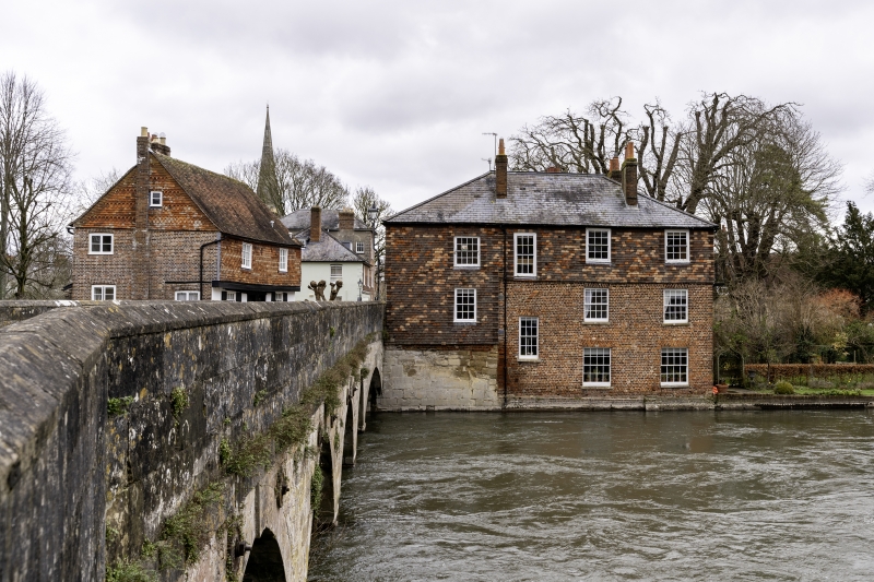
1.
1594 ST NICHOLAS'S ROAD
(East Side)
Nos 9 & 11
SU 1429 SW 5/352
II GV
2.
C18 and earlier. J storeys facing river. Red brick partly built on stone
bastion wall of bridge. Tile hanging, new, to 2nd floor. Low pitch hipped
slate roof. River front has irregular sash windows, some recessed, some with
flush architrave frames.
2 storeys facing bridge and road. Tile hung lst floor with 2 windows in flush
architrave frames and 2 on ground floor with modern glazed door in deep panelled
reveal. Renewed doorcase of panelled plaster cornice and pediment over.
Nos 7 to 11 (odd) form a group with Nos 16 & 18.
Listing NGR: SU1437129076
External links are from the relevant listing authority and, where applicable, Wikidata. Wikidata IDs may be related buildings as well as this specific building. If you want to add or update a link, you will need to do so by editing the Wikidata entry.


Other nearby listed buildings
