Approximate Location Map
Large Map »
Latitude: 51.9884 / 51°59'18"N
Longitude: -2.1637 / 2°9'49"W
OS Eastings: 388852
OS Northings: 232223
OS Grid: SO888322
Mapcode National: GBR 1JQ.CRN
Mapcode Global: VH93T.F9Z2
Plus Code: 9C3VXRQP+8G
Entry Name: Swilgate Bridge
Listing Date: 25 April 1994
Grade: II
Source: Historic England
Source ID: 1280309
English Heritage Legacy ID: 376760
ID on this website: 101280309
Location: Tewkesbury, Gloucestershire, GL20
County: Gloucestershire
District: Tewkesbury
Civil Parish: Tewkesbury
Built-Up Area: Tewkesbury
Traditional County: Gloucestershire
Lieutenancy Area (Ceremonial County): Gloucestershire
Church of England Parish: Tewkesbury St Mary the Virgin (Tewkesbury Abbey)
Church of England Diocese: Gloucester
Tagged with: Bridge
TEWKESBURY
SO83SE GLOUCESTER ROAD
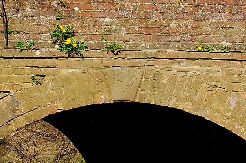
859-1/2/179 Swilgate Bridge
II
Road bridge over stream. 1635, repaired 1750, widened and
raised 1756 and 1827. Sandstone, brick, concrete.
A single arch bridge carrying the principal road from
Gloucester to Tewkesbury (turnpiked in the mid C18) with a
central section of good cut stone vaulting, but extended on
both sides with splayed brick abutments, and some filling and
stabilising in concrete.
The horizontal parapets have heavy sandstone weathered copings
and quoins, and are extended at the S end by 2 bays of simple
railing with 2 supporters. On the upstream side a central
keystone to the brick arch carries the date 1827. There is a
Bench Mark on the downstream parapet.
An early structure, pre-dating the turnpike road, which
originally forked to the W, to Lower Lode, just beyond this
bridge, before being brought to its present S alignment.
Formerly known as Holm Bridge, and mentioned as such in 1540;
said to have been a drawbridge until its rebuilding in stone
in 1635. It is probable that the central stone span is of this
date.
(Victoria County History: Gloucestershire: London: 1968-:
115).
Listing NGR: SO8885232223
External links are from the relevant listing authority and, where applicable, Wikidata. Wikidata IDs may be related buildings as well as this specific building. If you want to add or update a link, you will need to do so by editing the Wikidata entry.


Other nearby listed buildings
