Approximate Location Map
Large Map »
Latitude: 51.2119 / 51°12'42"N
Longitude: -2.6448 / 2°38'41"W
OS Eastings: 355056
OS Northings: 146057
OS Grid: ST550460
Mapcode National: GBR MN.3XDD
Mapcode Global: VH89S.3SNS
Plus Code: 9C3V6964+Q3
Entry Name: Front Boundary Wall to Ritchie Hall
Listing Date: 31 May 2000
Grade: II
Source: Historic England
Source ID: 1383167
English Heritage Legacy ID: 483585
ID on this website: 101383167
Location: St Andrew, Somerset, BA5
County: Somerset
District: Mendip
Civil Parish: Wells
Built-Up Area: Wells
Traditional County: Somerset
Lieutenancy Area (Ceremonial County): Somerset
Tagged with: Wall
WELLS
ST5446 THE LIBERTY
662-1/6/302 (North side)
No.5
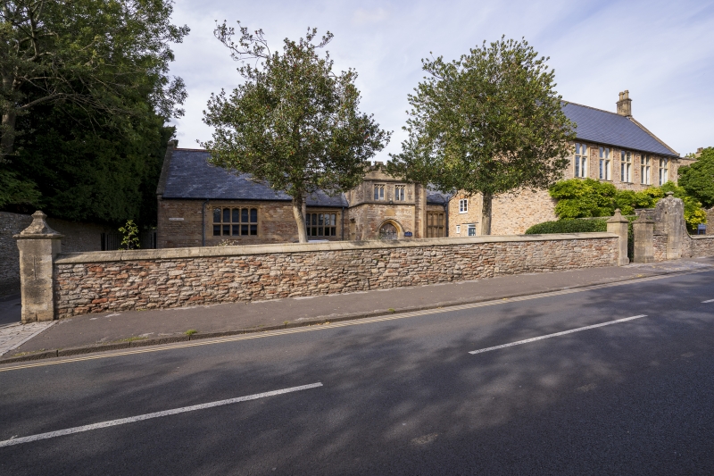
Front Boundary Wall to Ritchie Hall
GV II
Boundary wall with piers. Mid/late C19. Local coursed rubble
stone with ashlar dressings and piers. At the left, set back
approx 1m from the adjoining boundary wall to Polydor House
(qv), a pair of square ashlar gate piers with run-out chamfer
corners and to moulded cappings with a pair of simple iron
gates, then low wall with ogee-mould capping across full width
of front to a lower pair of square piers with swept cappings
to finials. The wall continues for approx 1.5m and is stopped
to a pier in the adjoining boundary wall (qv No.7).
Listing NGR: ST5505646057
External links are from the relevant listing authority and, where applicable, Wikidata. Wikidata IDs may be related buildings as well as this specific building. If you want to add or update a link, you will need to do so by editing the Wikidata entry.


Other nearby listed buildings
