Approximate Location Map
Large Map »
Latitude: 52.5379 / 52°32'16"N
Longitude: -2.8093 / 2°48'33"W
OS Eastings: 345207
OS Northings: 293650
OS Grid: SO452936
Mapcode National: GBR BG.F727
Mapcode Global: VH75V.8G6R
Plus Code: 9C4VG5QR+57
Entry Name: The Priory
Listing Date: 15 March 1974
Last Amended: 29 February 2000
Grade: II
Source: Historic England
Source ID: 1383264
English Heritage Legacy ID: 483682
ID on this website: 101383264
Location: Cunnery, Shropshire, SY6
County: Shropshire
Civil Parish: Church Stretton
Built-Up Area: Church Stretton
Traditional County: Shropshire
Lieutenancy Area (Ceremonial County): Shropshire
Church of England Parish: Church Stretton
Church of England Diocese: Hereford
Tagged with: Priory
CHURCH STRETTON
SO4593 CHURCH STREET
1312-1/13/41 (West side)
15/03/74 No.39
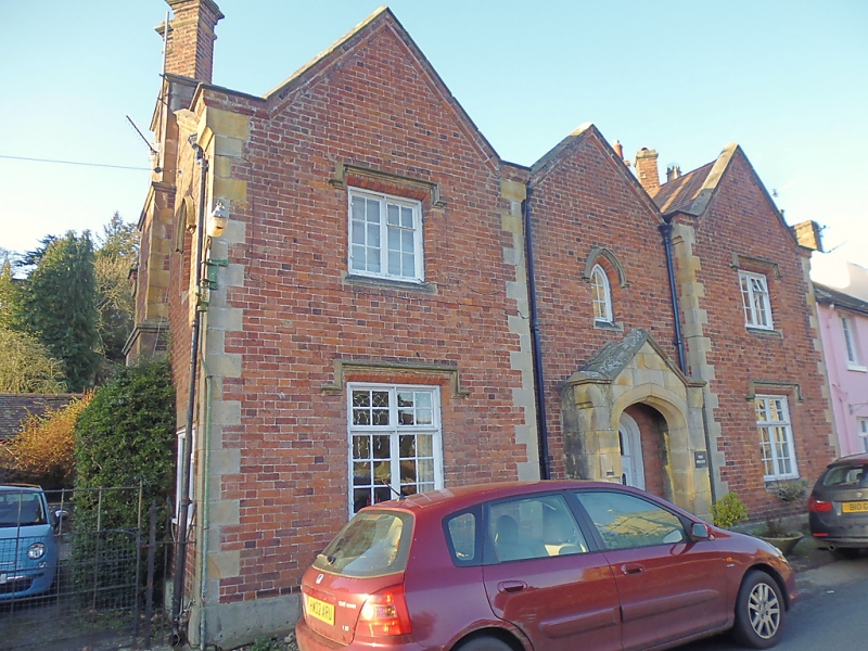
The Priory
(Formerly Listed as:
CHURCH STREET
The Priory)
GV II
House in Gothick style. Dated 1832. Red brick with rusticated
ashlar quoins and moulded brick dressings. Plain-tile roofs
with moulded brick parapet gables. Projecting brick stepped
gable-end stacks with twin diagonal shafts, those to the south
retaining stone string course and caps. H-shaped plan with
central range parallel with street.
EXTERIOR: 2 storeys. Street front with 3 parapet gables, the
centre being slightly recessed; mullioned and transomed
casement window with stepped dripmoulds to each bay; small
lancet window with dripmould in centre over door; projecting
ashlar porch with 4-centred archway and gable with
shield-shaped datestone. South side: central stack flanked by
first-floor lancets with dripmoulds and blind recessed windows
at ground level with that to the right replaced by a C20
casement. C20 windows to rear.
INTERIOR: not inspected.
Listing NGR: SO4520793650
External links are from the relevant listing authority and, where applicable, Wikidata. Wikidata IDs may be related buildings as well as this specific building. If you want to add or update a link, you will need to do so by editing the Wikidata entry.


Other nearby listed buildings
