Approximate Location Map
Large Map »
Latitude: 53.3692 / 53°22'9"N
Longitude: -1.489 / 1°29'20"W
OS Eastings: 434096
OS Northings: 385937
OS Grid: SK340859
Mapcode National: GBR 9CQ.81
Mapcode Global: WHDDP.3K6Y
Plus Code: 9C5W9G96+M9
Entry Name: Catacombs at Sheffield General Cemetery
Listing Date: 31 July 2001
Last Amended: 10 February 2009
Grade: II
Source: Historic England
Source ID: 1389316
English Heritage Legacy ID: 487958
ID on this website: 101389316
Location: Sharrow Head, Sheffield, South Yorkshire, S11
County: Sheffield
Electoral Ward/Division: Broomhill and Sharrow Vale
Parish: Non Civil Parish
Built-Up Area: Sheffield
Traditional County: Yorkshire
Lieutenancy Area (Ceremonial County): South Yorkshire
Church of England Parish: Endcliffe St Augustine
Church of England Diocese: Sheffield
Tagged with: Architectural structure
SHEFFIELD
784-1/0/10187 CEMETERY AVENUE
31-JUL-01 CATACOMBS AT SHEFFIELD GENERAL CEMETERY
(Formerly listed as:
CATACOMBS AT SHARROW CEMETERY)
II
Also Known As: CATACOMBS AT SHEFFIELD GENERAL CEMETERY, CEMETERY ROAD
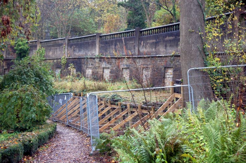
Two tiers of catacombs. 1836, enlarged 1935 and blocked late C20. Designed by Samuel Worth, the architect to the General Cemetery Company. Coursed and tooled rough ashlar with ashlar dressings and late C20 concrete additions.
Two serpentine curved and slightly battered walls form terraces running from east to west. The upper terrace wall is 130 metres long and 3 metres in height with roll moulded ashlar coping, topped by a late C20 blank concrete wall and concrete balustrade. This wall slopes downwards to the west. The lower terrace wall 100 metres long and approximately 2 metres high with a set of stone steps at the east end.
All the original openings to the original catacombs have battered surrounds. They have all been blocked.
Listing NGR: SK3498187017
External links are from the relevant listing authority and, where applicable, Wikidata. Wikidata IDs may be related buildings as well as this specific building. If you want to add or update a link, you will need to do so by editing the Wikidata entry.


Other nearby listed buildings
