Approximate Location Map
Large Map »
Latitude: 56.3351 / 56°20'6"N
Longitude: -2.7837 / 2°47'1"W
OS Eastings: 351646
OS Northings: 716138
OS Grid: NO516161
Mapcode National: GBR 2R.4Y9C
Mapcode Global: WH7S6.61Q7
Plus Code: 9C8V86P8+3G
Entry Name: 25 St Mary's Street Including Garden And Boundary Walls
Listing Name: 25 St Mary's Street Including Garden and Boundary Walls
Listing Date: 27 July 2007
Category: C
Source: Historic Scotland
Source ID: 399569
Historic Scotland Designation Reference: LB50927
Building Class: Cultural
ID on this website: 200399569
Location: St Andrews
County: Fife
Town: St Andrews
Electoral Ward: St Andrews
Traditional County: Fife
Tagged with: Architectural structure
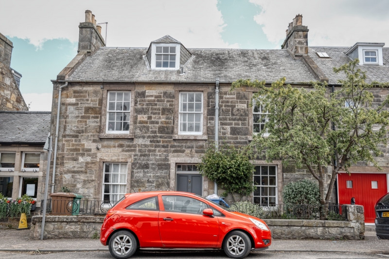
Early 19th century 2-storey and attic 3-bay simple Classical house situated in St Mary's Street. 4-panel timber door with 5-light rectangular fanlight to centre, windows in flanking bays, regular fenestration to 1st floor. Piended off-centre dormer to attic. Squared and coursed sandstone to street elevation, remaining elevations rubble. Raised ashlar margins.
12-pane timber sash and case windows with uPVC replacement to dormer. Graded grey slates with non-traditional rooflight at rear elevation. Ashlar coped gable stacks with cans. Ashlar-coped skews. Cast-iron rainwater goods.
GARDEN AND BOUNDARY WALLS: to W (street elevation) low coped section of wall with railings. To E high rubble semi-circular coped section of garden wall.
25 St Mary's Street is a fine example of an early 19th century simple Classical house. More commonly found in central St Andrews, this restrained style with careful proportions is important to the character of the town. 25 St Mary's Street is a good example of this type and is largely unaltered externally, retaining a 12-pane glazing pattern in timber sash and case windows.
The initial development of St Mary's Street began from 1812 and continued to the 1920s (Smart & Kenneth). John Wood's 1820 map of St Andrews shows that development at this time concentrated on the east side of the street including the site occupied by No 25, although the level of detail is not sufficient to accurately identify the buildings individually.
External links are from the relevant listing authority and, where applicable, Wikidata. Wikidata IDs may be related buildings as well as this specific building. If you want to add or update a link, you will need to do so by editing the Wikidata entry.


Other nearby listed buildings
