Approximate Location Map
Large Map »
Latitude: 51.696 / 51°41'45"N
Longitude: -4.8584 / 4°51'30"W
OS Eastings: 202550
OS Northings: 203560
OS Grid: SN025035
Mapcode National: GBR G9.TBFC
Mapcode Global: VH1S1.QMXQ
Plus Code: 9C3QM4WR+9J
Entry Name: Paskeston Hall
Listing Date: 14 May 1970
Last Amended: 12 September 1996
Grade: II
Source: Cadw
Source ID: 5957
Building Class: Domestic
ID on this website: 300005957
Location: At the N side of the unclassified road leading from Cosheston to Milton, in private grounds about 300 m from the road. There is a gate-lodge at the estate entrance. At the rear of the Hall are a coa
County: Pembrokeshire
Town: Pembroke Dock
Community: Cosheston
Community: Cosheston
Locality: Paskeston
Traditional County: Pembrokeshire
Tagged with: House
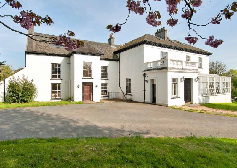
An early C18 house to which a much larger house has been added at the S. The new part was probably added c. 1835-55 by John Cooper, architect, of Pembroke Dock, and its semi-circular staircase built by James Leach, carpenter, also of Pembroke Dock. Paskeston Hall was the residence of the Roch family, who were important landowners in Cosheston. From the late C19 it was owned by the Allen family. It was requisitioned during the Second World War for prisoners and Land Army personnel, and was subsequently owned by the Parcell family until c.1972.
The early house is of two storeys plus an attic, with a large double-roofed rear wing. It faces W to the approach drive. Range of three windows to the front with a boldly advanced central section. Rubble masonry rendered and coloured light grey. The roof is of slate with a hipped extension over the advanced part. It has a deep eaves projection at the front. Large 12-pane sash windows with recessed frames and thin glazing bars.
C19 additions: a large extension was built at the S. Two storeys, roughcast and painted light grey. A low-pitched roof, slated and hipped, with boldly projecting eaves above a bracketed cornice. This extension is now the dominant mass of the building, to which the original house is in the relationship of a N wing. The new part has a separate entrance also facing W, but its main elevation is the S-facing garden front with a large segmental bow at its centre. To the garden front there are large 12-pane sash windows. The windows in the bow and the outer ground floor windows are tripartite sashes. All the windows have internal shutters. A flat-roofed entrance porch and a conservatory of timber and glass, both added in the late C19, extend along the W front.
In the 1970 list description the interior of the early house is said to have the following features: an early C18 staircase: square newels with capping; turned balusters and close string. A first-floor mantel has a dentil cornice, similar but simpler mantels at second floor level. Ground-floor doors with six sunk panels. Upper floor doors with two fielded panels. Panelled window shutters.
Listed as an important house of two periods, with early C18 features in the older N part and a finely proportioned garden front of Regency character in the recent S part.
External links are from the relevant listing authority and, where applicable, Wikidata. Wikidata IDs may be related buildings as well as this specific building. If you want to add or update a link, you will need to do so by editing the Wikidata entry.


Other nearby listed buildings
