Approximate Location Map
Large Map »
Latitude: 51.697 / 51°41'49"N
Longitude: -4.8764 / 4°52'34"W
OS Eastings: 201315
OS Northings: 203722
OS Grid: SN013037
Mapcode National: GBR G9.B5PS
Mapcode Global: VH1S1.FLFY
Plus Code: 9C3QM4WF+QF
Entry Name: Little Mayeston
Listing Date: 12 September 1996
Last Amended: 12 September 1996
Grade: II
Source: Cadw
Source ID: 17270
Building Class: Domestic
ID on this website: 300017270
Location: 1 km E of Cosheston village. From the unclassified road to Paskeston it is reached by a track to the S.
County: Pembrokeshire
Town: Pembroke Dock
Community: Cosheston
Community: Cosheston
Locality: Mayeston
Built-Up Area: Cosheston
Traditional County: Pembrokeshire
Tagged with: Architectural structure
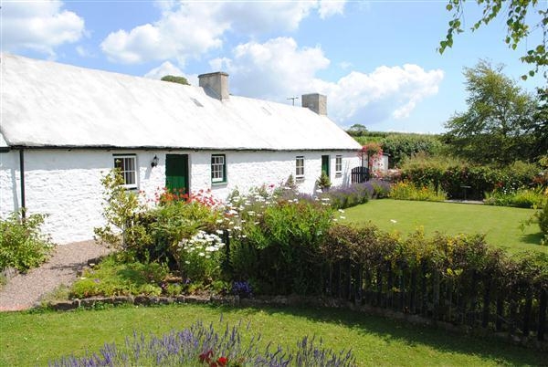
Little Mayeston was originally known as 'Mayeston'; in the C19 it came to be called Big Mayeston (in contrast to another Little Mayeston, which is now known as Mayeston Cottage). Since then Mayeston Farm has been built, and it is in contrast to the latter that the site is now called Little Mayeston.
This original Mayeston consisted of a pair of similar cottages probably of late C18 date. They faced S towards two very large vegetable gardens with a shared central path. The building remained two cottages until 1922. It was part of the Leach Estate, and the tenants in 1840 and 1850 appear to have been Richard Llewellyn and David James, a small farmer and a cottager. The pair was formed into one farmhouse in 1922. The right cottage (E) became the dwelling part. The right cottage underwent moderate adaptations but the left cottage was not altered, so it retains many original features. The building remained a farmhouse until 1978.
Random local stone rubble, heavily encrusted with limewash. Slate roof rendered on both slopes. Large stone chimneys at gable ends, with capping, and a small later chimney centrally. Each of the original cottages is of two units, single-storey, and has two windows facing S towards the vegetable gardens. At the left is a small dairy extension with its door to the rear. From left to right, the windows of the front (S) elevation consist of a fixed light of four panes, an original sash window with a three-pane sash above and a six-pane sash below, and two four-pane sash windows. The door of the left cottage is of three vertical boards, that of the right cottage is a replacement boarded door. Iron-sheeted sheds and a small extension at the rear.
The hearth of the right cottage has been altered for a Rayburn cooker, but the hearth of the left cottage is open and has a brick-lined bread oven complete with its cast-iron door. There are three large set-backs to the chimney. The left cottage is open to the roof and its croglofft is complete with an access ladder (removable) and a hatch in the boarded screen.
Listed as a fine vernacular structure which was recently two cottages with many important surviving features and an exellent S elevation.
External links are from the relevant listing authority and, where applicable, Wikidata. Wikidata IDs may be related buildings as well as this specific building. If you want to add or update a link, you will need to do so by editing the Wikidata entry.


Other nearby listed buildings
