Approximate Location Map
Large Map »
Latitude: 51.706 / 51°42'21"N
Longitude: -4.8664 / 4°51'58"W
OS Eastings: 202046
OS Northings: 204694
OS Grid: SN020046
Mapcode National: GBR G9.SNC5
Mapcode Global: VH1S1.LDQ1
Plus Code: 9C3QP44M+9F
Entry Name: Upton Castle
Listing Date: 14 May 1970
Last Amended: 12 September 1996
Grade: I
Source: Cadw
Source ID: 6031
Building Class: Domestic
ID on this website: 300006031
Location: 2 km NE of Cosheston village, reached by a side road N of the unclassified Cosheston to Milton Road which becomes a private road from Upton Lodge. The entrance front of the house faces N.
County: Pembrokeshire
Town: Pembroke Dock
Community: Cosheston
Community: Cosheston
Locality: Upton
Traditional County: Pembrokeshire
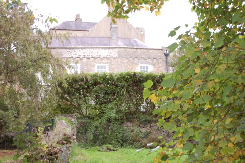
From the C13 Upton Castle was the residence of the Malefants, who were barons dependant on the Earldom of Pembroke. The towers and upper-floor hall of the early residence survive as the NE part of the present building. The form of the building as remaining and the lack of secondary defences suggest it would be better described as simply a fortified house, though the name Castle is too established to drop. In the early parts there are trefoil-headed windows probably datable to the C14. An early first-floor doorway with ladder access was located in the centre of the curtain wall between the E and centre towers, and it is illustrated on a drawing of c.1800.
In the C15 the castle passed by marriage from the Malefants to a line which assumed the name Bowen. The castle was greatly enlarged in the C17 and C19 with extensions to the S and the W. In the late C18 it was sold to John Tasker, when it was in ruinous condition; it was described thus by Carlisle in 1811. Later it passed, by the marriage of Tasker's niece, to the Rev William Evans. Alterations to the entrance were considered c.1823, and the present entrance between central and W towers existed by 1858. Later owners were John Tasker Evans, d.1895, and Adm. Richard Evans, d.1927. In 1927 the Castle was sold to Stanley Neale, in whose family it remains.
Alterations carried out in the 1860s, when for a time the Castle was leased to a tenant, led to some litigation over defects in the work for which John Cooper, of Pembroke Dock, was the architect.
The castle grounds were taken into the care of the National Park and were opened to the public in 1976.
The original part is at the NE, with very large extensions later to S and W. The form of the early house has been obscured by C19 alterations, including the isertion of a new first floor. It was a house aligned E/W with first floor access on both N and S sides. The first floor had a fireplace against the S wall and windows to S and E. A stair in the central tower led up to the second floor, where the main hall appears to have been, with a fireplace against the N side and a service room to the W. Three early towers, the E one virtually circular and the others semi-circular, separated by short lengths of curtain wall, constitute the N elevation of the medieval part. These are in a masonry of large irregular courses, with plain parapets standing on corbel tables. The corbel table of the tower to the W is at a lower level. The position of the original first-floor entrance, in the curtain between centre and E towers, is now occupied by an early C19 arch above a window and door. At higher level there is a blocked window with a trefoil head. The present entrance to the house is between the central and W towers, with two wall-arches above and two blocked quatrefoil loops. In the E and the central towers there are cross-loops with oillets. In the S-facing elevation of the medieval part there is a window with a trefoil headed opening to the ground storey, and a doorway with a dressed stone arch which has a broach-stop. There is a parapet on corbels with small crenellations.
There is an early extension to the S of four storeys, probably late C17, and there are large C19 extensions W, S, and again W. To the N of the four-storey extension is a passageway with a glazed roof. It leads through to the gardens at the rear and also gives access to the main part of the house. All the later work is in similar stone to the original, but in smaller rubble masonry, and the walls terminates in two large contiguous bow fronts facing the main approach, evidently intended to repeat the theme of the tower-dominated original N front.
The windows of the later parts and of the early W tower are all, except the smallest, four-pane mid-C19 sash windows with exposed frames.
In the medieval part the centre-tower has a vaulted ceiling. There is the cambered voussoir head of a fireplace in the first storey against the S wall. The stair in the centre tower leading to the original hall on the second floor is a stone spiral with a dressed limestone newel. The fireplace in the second-floor hall has square-headed dressed stone hood on quarter-round corbels. the original roof was based on corbels below the wall-head height. In the C17 part there is a fine staircase with a close string and square newels and balusters. There is a decorative plasterwork perimeter to the sitting room ceiling at first floor.
Listed Grade I as a medieval fortified house subsidiary to Pembroke Castle and a rare building type surviving in a good state of completeness. It has many surviving original features and was developed into a gentleman's country house in a fortified style.
External links are from the relevant listing authority and, where applicable, Wikidata. Wikidata IDs may be related buildings as well as this specific building. If you want to add or update a link, you will need to do so by editing the Wikidata entry.


Other nearby listed buildings
