Approximate Location Map
Large Map »
Latitude: 51.6773 / 51°40'38"N
Longitude: -4.9181 / 4°55'5"W
OS Eastings: 198340
OS Northings: 201643
OS Grid: SM983016
Mapcode National: GBR G8.W6PV
Mapcode Global: VH1S6.P3TJ
Plus Code: 9C3QM3GJ+WP
Entry Name: The Mill Bridge
Listing Date: 14 July 1981
Last Amended: 29 July 2005
Grade: II
Source: Cadw
Source ID: 6424
Building Class: Transport
ID on this website: 300006424
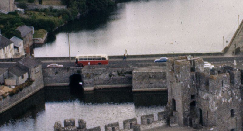
Location: Crossing the estuary and Mill Pond N of the old town and some 100m E of the castle.
County: Pembrokeshire
Town: Pembroke
Community: Pembroke (Penfro)
Community: Pembroke
Built-Up Area: Pembroke
Traditional County: Pembrokeshire
Tagged with: Bridge Road bridge
An ancient causeway bridge across the mill pond, rebuilt in early C19. A multi-arched bridge is shown on John Speed's 1610 map, but a battlemented causeway is shown in the 1748 Buck view with a sluice towards the N end and a gabled mill on the W side towards the S end. Provision for the tidal mill was first granted in 1199 by King John to the Knights Templar. In its later form it was a large four storey and attic building described as new-built in 1821, and a narrower two-storey range to N, the outline of both ranges marked by low walls on the bridge and projections on the W side. It was burnt in 1885, restored 1887, burnt 1955 and demolished. The causeway was probably much rebuilt when the mill was built c. 1820 as the masonry of the base of the mill looks early C19 and the rest is not dissimilar. Two arches, one for the mill and one towards N for the sluice.
Causeway, stepped out twice on the W side for the base of the demolished c. 1820 mill and its narrower N wing. The short section of main causeway to left on W has the lower part faced with squared stone in regular courses, the upper part is slightly set back and of rubble with flat grey limestone parapet coping stones. Sluice gate arch with tooled squared stone voussoirs and keystone. Projection for N wing of mill has large raking buttress of squared stone. Main mill projection has a large segmental arch towards the right with raised voussoirs of cut stone. The mill walls have been taken down to parapet level of the causeway, with similar copings. Short length of causeway to right of projection.
On E side, continuous masonry with squared stone in regular courses to lower part and rubble above, coped parapet. Raised arch of cut stone to mill on left, flush similar arch to sluice on right.
The surviving low walls of the mill have entrances at S end and on E.
Included for its special interest as a fine stone causeway bridge, part of the setting of Pembroke castle and town.
External links are from the relevant listing authority and, where applicable, Wikidata. Wikidata IDs may be related buildings as well as this specific building. If you want to add or update a link, you will need to do so by editing the Wikidata entry.


Other nearby listed buildings
