History in Structure

Limekiln on S.Side of Estuary

A Grade II Listed Building in Solva, Pembrokeshire

We don't have any photos of this building yet. Why don't you be the first to send us one?

Upload Photo »

Approximate Location Map
Large Map »

Coordinates

Latitude: 51.8726 / 51°52'21"N

Longitude: -5.1902 / 5°11'24"W

OS Eastings: 180483

OS Northings: 224149

OS Grid: SM804241

Mapcode National: GBR C8.SC7R

Mapcode Global: VH0TM.Z6H9

Plus Code: 9C3PVRF5+2W

Entry Name: Limekiln on S.Side of Estuary

Listing Date: 4 February 1991

Last Amended: 4 February 1991

Grade: II

Source: Cadw

Source ID: 12455

Building Class: Industrial

ID on this website: 300012455

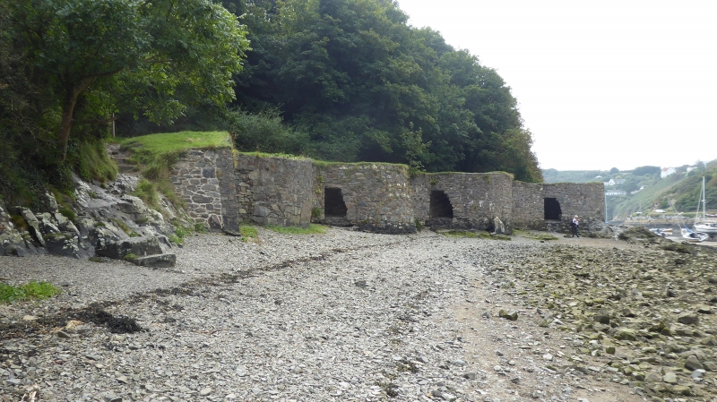
Location: Situated on foreshore just above high water line, on southern side of Solva harbour some 300m SW of Harbour House Hotel.

County: Pembrokeshire

Community: Solva (Solfach)

Community: Solva

Locality: Solfach Isaf/Lower Solva

Built-Up Area: Solva

Tagged with: Lime kiln

Find accommodation in
Solva

History

Later C18 to early C19

Exterior

Row of four rubble stone limekilns, restored 1981-2, built into estuary bank above high water line. All roughly circular and with Dewisland type kiln-eyes, with sloping heads up to short stone lintel. Circular crucibles, filled-in except on further kiln which has been most completely restored, the others having been repointed and stabilised. Between the third and fourth kilns are exposed the foundations of a small watchman’s hut. The first, or nearest kiln, is the most roughly built and was added later as only three, with the watchman’s hut, are shown in a watercolour of 1795. Four kilns are shown on an 1839 plan.

Scheduled Ancient Monument: Pe 378

External Links

External links are from the relevant listing authority and, where applicable, Wikidata. Wikidata IDs may be related buildings as well as this specific building. If you want to add or update a link, you will need to do so by editing the Wikidata entry.

Recommended Books

Other nearby listed buildings

  • II Limekiln on S.Side of Estuary
    Situated on foreshore just above high water line, on southern side of Solva harbour some 300m SW of Harbour House Hotel.
  • II Limekiln on S.Side of Esturay
    Situated on foreshore just above high water line, on southern side of Solva harbour some 300m SW of Harbour House Hotel.
  • II Limekiln on S.Side of Estuary
    Situated on foreshore just above high water line, on southern side of Solva harbour some 300m SW of Harbour House Hotel.
  • II War Memorial
    Situated towards the top of hill between Lower and Upper Solva, before junction with Pen-yr-Aber.
  • II Glan y Mor
    Situated facing E on first part of PenYr Aber at corner of access lane to Nos 6 to 12.
  • II Limekiln adjacent to Brookside
    Situated on eastern side of footpath beyond children’s playground.
  • II Gwyryd House
    Situated towards western end of street, the last house in the continuous terrace.
  • II The Old Printing House
    Situated on northern side opposite The Ship Inn.

BritishListedBuildings.co.uk is an independent online resource and is not associated with any government department. All government data published here is used under licence. Please do not contact BritishListedBuildings.co.uk for any queries related to any individual listed building, planning permission related to listed buildings or the listing process itself.

British Listed Buildings is a Good Stuff website.