Approximate Location Map
Large Map »
Latitude: 53.1551 / 53°9'18"N
Longitude: -3.2003 / 3°12'1"W
OS Eastings: 319831
OS Northings: 362668
OS Grid: SJ198626
Mapcode National: GBR 6X.593K
Mapcode Global: WH774.TY7M
Plus Code: 9C5R5Q4X+2V
Entry Name: Pentre Mill (including Sluice and Cast Iron Flume to rear)
Listing Date: 16 October 1995
Last Amended: 29 January 1996
Grade: II
Source: Cadw
Source ID: 16443
Building Class: Industrial
ID on this website: 300016443
Location: Situated in the Loggerheads Country Park 0.2 km N of the Loggerheads PH, reached from a drive running N from the A494 at its junction with the by road to Cilcain.
County: Denbighshire
Community: Llanferres
Community: Llanferres
Locality: Loggerheads
Traditional County: Denbighshire
Tagged with: Mill Mill building
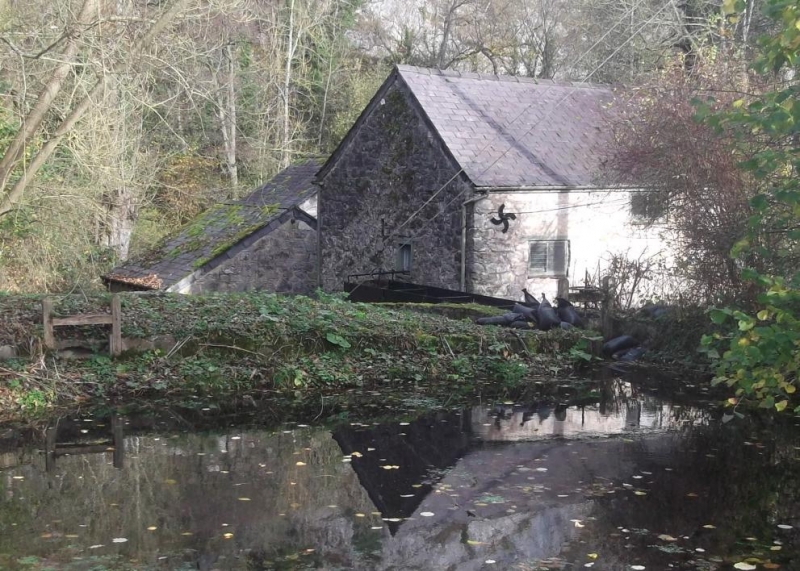
Early C19, on the site of an earlier building shown in a print dated 1796, the mill was used to grind corn and to power a circular saw. The roof was raised, perhaps later C19 to provide more space on the grain floor. It was in continuous use until 1942 at which time it was being used to make cattle feed. The mill was restored and opened to the public by Clwyd County Council in 1980.
Rubble with roughly squared quoins, slate roof, 3 storeys. Windows are all horizontally sliding sashes reglazed and restored 1980. Elevation to yard has ground floor entrance with cambered arch with boarded doors and a small window above. The position of a lower steeply pitched roofline is visible in the masonry. Right hand return has a timber external stair leading to a door, a small window to the right and one small window to upper floor. Left hand return has one small centrally placed window to the ground and upper floor, 2 larger windows to first floor. Rear elevation has an overshot cast iron waterwheel with the makers name, R & W Jones Ruabon, fed by a cast iron flume by the same makers. There is a small window and a ventilation slit above the wheel and the line of the former roof can be seen in the masonry. The flume connects to a sluice with gates renewed 1980.
Not accessible at time of 1995 survey, but recorded as containing working machinery restored with some replacements, 1980. Ground floor has millstones set into the floor, drive floor to rear with mill machinery. First floor retains further mill stones and upper floor has sack hoists etc.
Listed as a good example of a small watermill which retains many original features with an intact power transmission system. Pentre Mill is the only example in the area of a series of mills along the river to survive in relatively intact condition.
External links are from the relevant listing authority and, where applicable, Wikidata. Wikidata IDs may be related buildings as well as this specific building. If you want to add or update a link, you will need to do so by editing the Wikidata entry.


Other nearby listed buildings
