Approximate Location Map
Large Map »
Latitude: 51.4561 / 51°27'21"N
Longitude: -3.4955 / 3°29'43"W
OS Eastings: 296191
OS Northings: 174072
OS Grid: SS961740
Mapcode National: GBR HH.MKGX
Mapcode Global: VH5HS.CNFM
Plus Code: 9C3RFG43+CR
Entry Name: Former Church School
Listing Date: 26 October 1995
Last Amended: 26 October 1995
Grade: II
Source: Cadw
Source ID: 16464
Building Class: Education
ID on this website: 300016464
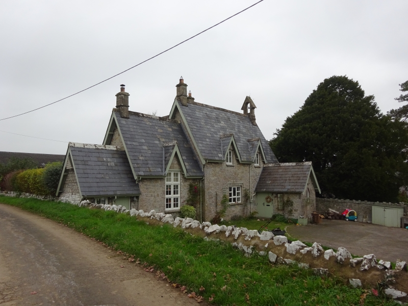
Location: Prominently located at the centre of Llysworney village to the S of the parish church, set back from the road within a small paved yard surrounded by a low rubble wall.
County: Vale of Glamorgan
Community: Llandow (Llandŵ)
Community: Llandow
Locality: Llysworney
Traditional County: Glamorgan
Tagged with: School building
Victorian former village school with date stone on the front elevation inscribed "1858 by RCNC" referring to R.C Nicholl Carne whose wife is commemorated in the parish church of St Tydfil. Strong composition with distinctive asymmetric plan unusual in that the schoolhall is stepped down from the schoolhouse. Primarily two storeys high, coursed limestone elevations and steeply pitched Welsh slated roofs. The main range is aligned on a N/S axis with a two storey range to the rear. The lower range to the S steps down in height with a single storey range at the far S end. Three ashlar stacks, one to each two storey range with bellcote to N end of main block, retaining one bell. Pronounced gables rising from the eaves with plain bargeboards to all main elevations with timber casements beneath. Single storey porch to N end of main range, with a pair of boarded double doors and small lancet window to the front elevation with inscribed plaque above. Ground floor has three-light window set centrally between the first floor casements. The main range (hall) is double-height with a 2-light, twin-transomed small-pane window. Similar window to N gable end. Single storey bay to S end has single timber boarded door with four pane sash to left hand side. Further casements to rear set beneath gable on central range with larger casement beneath to ground floor. S elevation of rear range has further gable with casement arrangement and boarded door with sash to right hand side with hoodmould over. Single storey lean-to with slated roof to N elevation.
Listed grade II as a well designed mid C19 school bordering the churchyard at the centre of the village and having group value with the church and the Great House.
External links are from the relevant listing authority and, where applicable, Wikidata. Wikidata IDs may be related buildings as well as this specific building. If you want to add or update a link, you will need to do so by editing the Wikidata entry.


Other nearby listed buildings
