Approximate Location Map
Large Map »
Latitude: 51.6965 / 51°41'47"N
Longitude: -4.888 / 4°53'16"W
OS Eastings: 200508
OS Northings: 203699
OS Grid: SN005036
Mapcode National: GBR G9.B8LN
Mapcode Global: VH1S1.7M8B
Plus Code: 9C3QM4W6+JQ
Entry Name: Funeral Car Tenement
Listing Date: 12 September 1996
Last Amended: 12 September 1996
Grade: II
Source: Cadw
Source ID: 17267
Building Class: Religious, Ritual and Funerary
ID on this website: 300017267
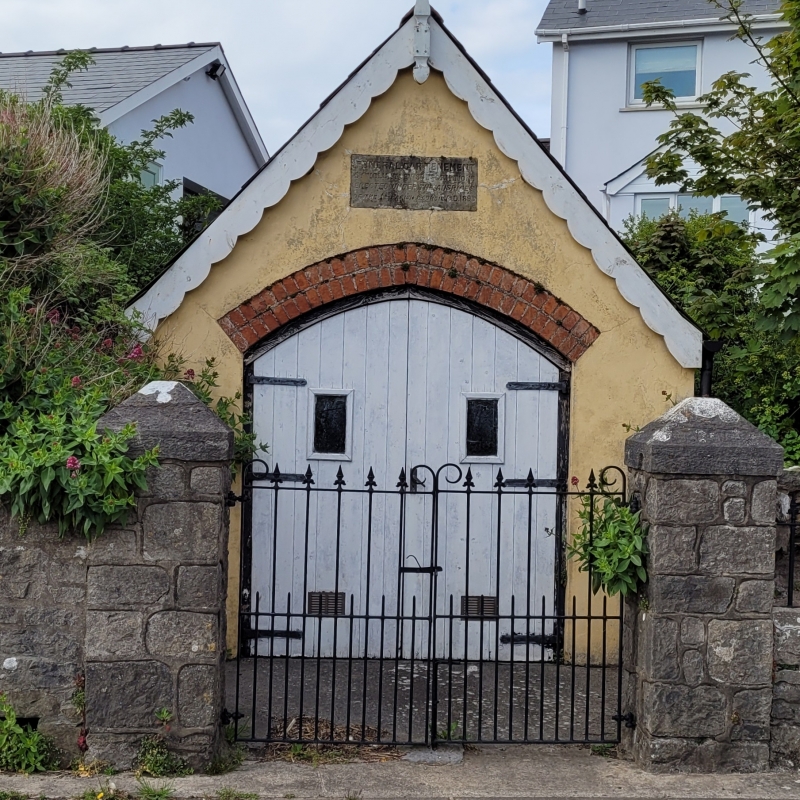
Location: At the N side of the main village street in Cosheston, about 50 m E of the crossroads. It is in a walled enclosure with steel gates in front, hung on stone gatepiers with steeply weathered copings.
County: Pembrokeshire
Town: Pembroke Dock
Community: Cosheston
Community: Cosheston
Locality: Cosheston Village
Built-Up Area: Cosheston
Traditional County: Pembrokeshire
Tagged with: Architectural structure
Subscriptions were raised in 1895 for the construction of a tenement for the parish funeral car. Money was also donated by the Band of Hope and the funds were further augmented by the proceeds of a concert. From the receipts and expenditure account published at this time it appears a new funeral car was also purchased. From 1896 the building was vested in the Parish Council. The original cast-iron gates have been lost. The tenement was restored c.1980. In 1995 to mark its centenary it was again restored by the Community Council. It still houses the car.
A single-room building about 3 m by 4 m, with its gable and doors facing S to the village street. Stone walls, rendered and painted. Slate roof with restored bargeboards and finial. Boarded double doors at front with small glazed panels, under a slightly pointed segmental brick arch. A small plaque in the gable records that the building was funded by voluntary contributions.
Listed as a good, well-preserved example of a minor building type, remaining in its original use.
External links are from the relevant listing authority and, where applicable, Wikidata. Wikidata IDs may be related buildings as well as this specific building. If you want to add or update a link, you will need to do so by editing the Wikidata entry.


Other nearby listed buildings
