History in Structure

The Smithy

A Grade II Listed Building in Manafon, Powys

More Photos »
Approximate Location Map
Large Map »

Coordinates

Latitude: 52.6123 / 52°36'44"N

Longitude: -3.3129 / 3°18'46"W

OS Eastings: 311198

OS Northings: 302423

OS Grid: SJ111024

Mapcode National: GBR 9S.8H0P

Mapcode Global: WH79T.2LPP

Plus Code: 9C4RJM6P+WR

Entry Name: The Smithy

Listing Date: 4 February 1997

Last Amended: 4 February 1997

Grade: II

Source: Cadw

Source ID: 18229

Building Class: Domestic

ID on this website: 300018229

Location: Located close to the road at the W end of the village, with the smithy immediately to the right, and two mid C20 hand operated Avery-Hardoll petrol pumps with illuminated globes to the left.

County: Powys

Town: Manafon

Community: Manafon

Community: Manafon

Traditional County: Montgomeryshire

Tagged with: Smithy

Find accommodation in
Tregynon

History

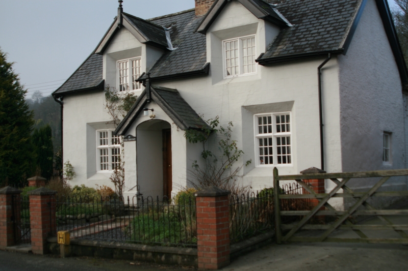
A house built by the Vaynor estate in the mid C19, which at one stage accommodated the village blacksmith.

Exterior

Rendered and lined over stone. Slate roof. Two storeys, 2 bays, with a 2-storey short rear wing. Front elevation is bilaterally symmetrical, with a central gabled porch with a segmental headed outer arch leading to a C20 oak front door set in the original chamfered frame. Paned moulded timber cross windows set in deep chamfered surrounds. The upper floor has two raised and gabled dormers with similar surrounds. The dormer bargeboards terminate in spike finials, as do the main end gables. End slate hung. Central stack built of buff brick, with 2 diagonally set shafts.

Interior

Interior not accessible at the time of inspection (Sept 1996).

Reasons for Listing

Included as a well detailed and carefully preserved example of a C19 estate cottage, of group value with its smithy adjoining.

External Links

External links are from the relevant listing authority and, where applicable, Wikidata. Wikidata IDs may be related buildings as well as this specific building. If you want to add or update a link, you will need to do so by editing the Wikidata entry.

Recommended Books

Other nearby listed buildings

  • II Manafon smithy
    Located immediately E of The Smithy cottage, at the E end of Manafon village centre.
  • II Lych gate to the churchyard, Church of St Michael and All Angels.
    Located in the S corner of the churchyard and opening directly on to the main road. Immediately to the E is the granite war memorial.
  • II* Church of St Michael and All Angels
    The church stands centrally in the formerly oval churchyard, at the centre of the village. The churchyard, which was extended c.1926, has a lych-gate (q.v.) and a granite war memorial in the S corner
  • II The Grange, also known as The Old Rectory
    Set back from the road in a riverside position, directly off a small lane. The former coachhouse and stable lies to the E.
  • II Bron-y-rhiw Cottage
    Located above the S bank of the Afon Rhiw, at the end of the small lane leading S off the main Berriew to Llanfair Caereinion road, leading past the Old Rectory.
  • II Hen llys
    Located on rising ground about 200m N of the road, and accessed by a driveway through the former farm buildings.
  • II Dol-terfyn
    Set close to and parallel with the main Manafon to Berriew Road, immediately E of The Green.
  • II Mynachdy Sant Elias
    Located in the centre of the hamlet, in the E angle of the junction of the B4390 Tregynon to Berriew Road with the road to Llanfair Caereinion.

BritishListedBuildings.co.uk is an independent online resource and is not associated with any government department. All government data published here is used under licence. Please do not contact BritishListedBuildings.co.uk for any queries related to any individual listed building, planning permission related to listed buildings or the listing process itself.

British Listed Buildings is a Good Stuff website.