Approximate Location Map
Large Map »
Latitude: 51.6962 / 51°41'46"N
Longitude: -3.0246 / 3°1'28"W
OS Eastings: 329278
OS Northings: 200216
OS Grid: SO292002
Mapcode National: GBR J4.49X8
Mapcode Global: VH79S.JMCJ
Plus Code: 9C3RMXWG+F4
Entry Name: Tramroad and leat tunnels, Monmouthshire and Brecon Canal
Listing Date: 28 August 1997
Last Amended: 28 August 1997
Grade: II
Source: Cadw
Source ID: 18833
Building Class: Transport
ID on this website: 300018833
Location: Approached from Fountain Road about 400m south-east of Pontymoile roundabout.
County: Torfaen
Town: Pontypool
Community: Pontymoile (Llanfihangel Pont-y-moel)
Community: Pontymoile
Built-Up Area: Pontypool
Traditional County: Monmouthshire
Tagged with: Tunnel
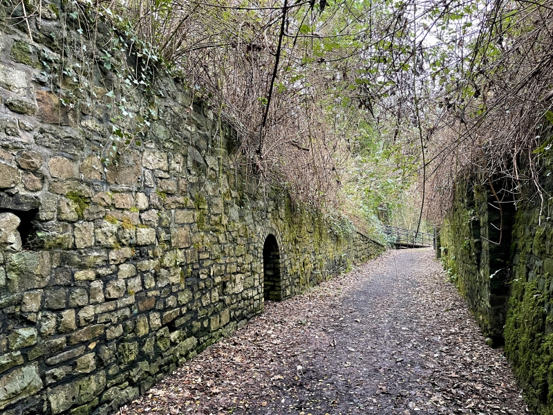
The Brecknock and Abergavenny Canal was promoted in 1792 to connect the upper Usk valley to the Monmouthshire Canal at Pontymoile and from there to the sea at Newport. Construction began in 1797, with Thomas Dadford Jnr. as engineer, and the first section, from Gilwern to Llangynidr was completed in that year with the stretch as far as Brecon following in 1800. Work then stopped for a time with the result that the section to the Blaenavon Road east of Govilon was not completed until 1805, now with Thomas Cartwright as engineer. Further funds had to be raised and the last section from west of Llanfoist to Pontymoile was completed betwen 1809 and 1812, with William Crosley as engineer. Linked to the tramroads the canal was an important artery for trade in iron, lime and coal. In 1865 the Monmouthshire and the Brecknock and Abergavenny Canal Companies merged becoming the Monmouthshire and Brecon Canal Company. Later still in 1880 the canal was bought out by the Great Western Railway and gradually the canal was run down until it was abandoned finally in 1962. Restoration work was begun in 1964, and the canal is once again open between Pontymoile and Brecon with the title Monmouthshire and Brecon Canal. The larger tunnel was constructed to carry a tramway running down from the Pontymoile Tinplate Works to Lower Mill; while the smaller tunnel carried a 'feeder' or water supply (probably in an iron pipe) to Lower Mill, but it is uncertain whether they were pre-existing; they are shown on the tithe map of 1839.
A paired tunnel of dressed semi-circular arches with a 1m thick pier between. Coursed squared stone revetment into the embankment on either side and above the arches. Same treatment on both faces. The smaller (eastern) tunnel was for a watercourse, the larger for a tramway, but it is uncertain whether they pre-existed the canal.
The tunnels are lined and paved with stone. Headroom about 2m in centre of arch.
An interesting structure surviving unaltered and in use from this important canal.
External links are from the relevant listing authority and, where applicable, Wikidata. Wikidata IDs may be related buildings as well as this specific building. If you want to add or update a link, you will need to do so by editing the Wikidata entry.


Other nearby listed buildings
