Approximate Location Map
Large Map »
Latitude: 51.474 / 51°28'26"N
Longitude: -3.702 / 3°42'7"W
OS Eastings: 281891
OS Northings: 176374
OS Grid: SS818763
Mapcode National: GBR H7.L7KG
Mapcode Global: VH5HN.S68W
Plus Code: 9C3RF7FX+H6
Entry Name: The Look-out Tower
Listing Date: 17 February 1998
Last Amended: 17 February 1998
Grade: II
Source: Cadw
Source ID: 19359
Building Class: Communications
Also known as: The Look-out Tower
ID on this website: 300019359
Location: At the extreme E end of the Promenade adjacent to the Breakwater on the very edge of the sea wall.
County: Bridgend
Town: Porthcawl
Community: Porthcawl
Community: Porthcawl
Locality: Porthcawl Harbour
Built-Up Area: Porthcawl
Traditional County: Glamorgan
Tagged with: Observation tower
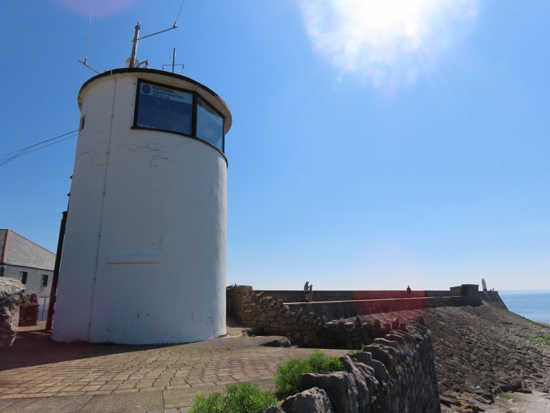
Part of a complex formerly comprising the lighthouse on the Breakwater 1866, signal station now demolished and lifeboat station inaugurated 1860 and now rebuilt, to provide guidance and a rescue service for sailors in the surrounding treacherous seaways, the site of many wrecks. First coastguard service in Porthcawl 1830s. This building of unknown date is thought to have been constructed after the harbour extension of 1867 and appears on 1st edition OS Map 1885 (surveyed 1876). Shown on a photograph of c1900 much as now but with small-paned lookout windows, also one on seaward side at ground floor, and possibly a chimney.
A circular tower, slightly tapered, rendered and white painted, a small gap in the rendering shows stone rubble originally limewashed. Flat roof now of concrete supported internally by cast iron piers on the seaward side where there are 4 replaced large glazed viewing panels. 2 protruding ledges at eye level on each side of unknown purpose. At upper floor right is a small recessed light apparently unaltered facing town. To rear are doors on each level with iron lintels, and keystone to ground floor which also has large stone step. Timber flight of steps to first floor. Sea guidance lights and flag poles on roof.
Listed for its local interest as a building representing the maritime guidance and rescue service provided by the dock in the mid C19; group value with the Outer Basin, the Breakwater, Jennings Warehouse, the Old Customs House, and the Lighthouse.
External links are from the relevant listing authority and, where applicable, Wikidata. Wikidata IDs may be related buildings as well as this specific building. If you want to add or update a link, you will need to do so by editing the Wikidata entry.


Other nearby listed buildings
